
A black bear emerges from her den in the early days of spring. The snow has melted in Vermont’s Green Mountains and percolated through the soil layers to become groundwater. The blossoming red maples create a maroon haze amongst the still bare yellow birch and sugar maple crowns. With the fat reserves the bear built up last fall now depleted, she searches for greenery to consume.
In this area where upland forest and wetlands meet, the thawing, barren ground is already peppered with green shoots. Each of the bear’s steps sinks deeper than the last. She returns to this area for many weeks, and the vegetation here will comprise much of her diet until berries and fruit form in midsummer.
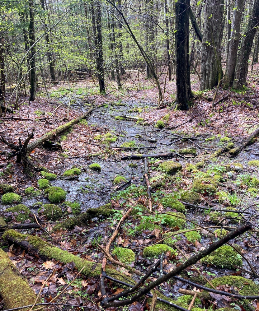
This bear is foraging in a seepage forest, a natural community that is relatively new to Vermont ecologists’ vernacular. (A natural community is a collection of plant and animal populations occurring in a specific environment, plus the processes influencing them.) Seepage forests are wet forests that occur where a steep slope meets a gentler one with an impermeable layer underneath, forcing groundwater to surface and saturate the soil layer above.
This natural community type exists throughout Vermont as well as in northern New Hampshire and Maine. Seepage forests average around 25 acres, and – based on surrounding forest type and elevation – may feature hardwoods and softwoods, along with a variety of wetland and upland herbaceous plants. This high plant diversity, importance to wildlife, and ability to slow water movement make seepage forests a critical natural community in the face of climate change and biodiversity loss. Vermont Fish & Wildlife, New Hampshire Division of Forests & Lands, and Maine Department of Agriculture, Conservation & Forestry have each developed recommended management guidelines to protect seepage forests.
Ecologists define seepage forests by their geology and hydrology. At the base of a slope, there is a compacted layer of basal till, deposited 25,000 years ago when the Laurentide ice sheet was fluctuating across New England. After melting, dropping suspended sediments, and refreezing, the glacier continued to flow southward, compressing the till under a vertical mile of ice. As groundwater travels downslope, this nearly impermeable till forces the groundwater to the surface, where it seeps from the base of the slope and saturates the thin layer of soil resting on top. The temperature of the groundwater in early spring is warm enough for the seepage forest’s soils to thaw before the surrounding upland forest, and the groundwater in seepage forests remains cool during the height of summer. Wetland species of dwarf raspberry, false hellebore, foam flower, and many others thrive in these saturated soils. The boundary of this community is dictated by the spread of this wet soil layer, which acts as a sponge, holding the water within this community and slowly releasing it at the edge as streams.
Balsam fir, yellow birch, and red spruce dominate seepage forests above 2,000 feet in elevation, while yellow birch, sugar maple, and black ash are present in lower elevation seepage forests. The tree species composition in seepage forests and the drier surrounding upland forests tend to resemble one another because of seepage forests’ microtopography. When shallow-rooted trees tip up from the wet soil, their vertical root masses decompose to create small hills, or hummocks, within the wetland. The next generation of trees and other upland plants survives perched above the water table on these drier mounds.
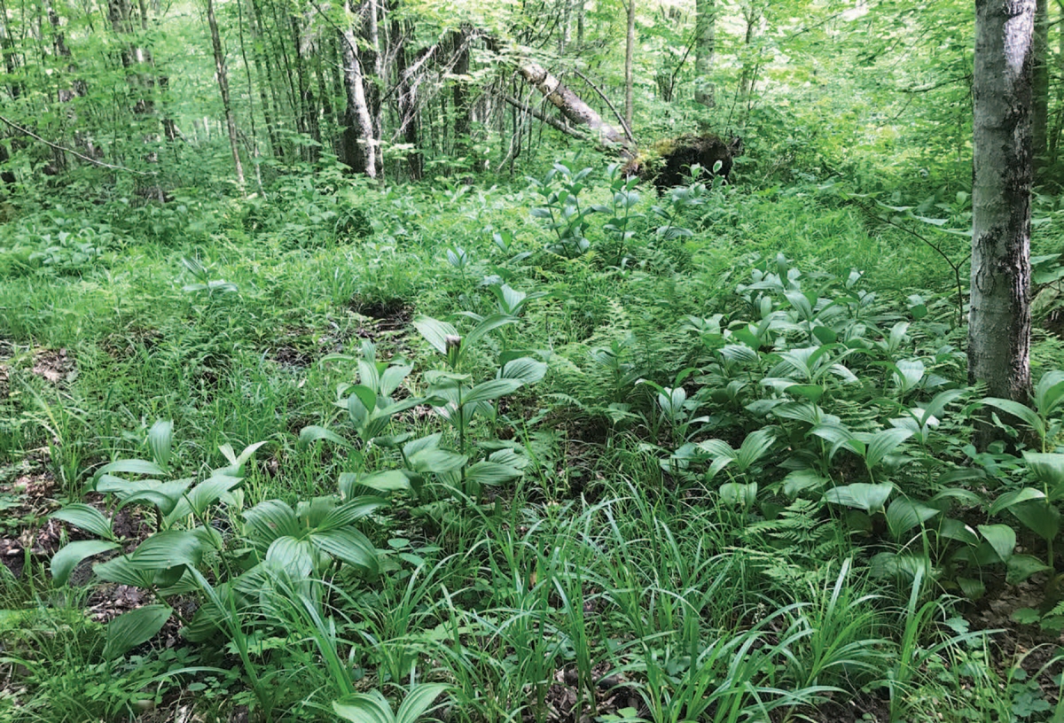
The delicate spatial interplay between wetland and upland plant species leads to unusually high diversity. In 2021, for instance, Dan Farrell, assistant ecologist at Vermont Fish & Wildlife, documented a single northern hardwood seepage forest comprising more than 135 vascular plant species. These species, he said, range from “wetland to upland, shade-loving to sun-loving, and nutrient-loving, occurring side-by-side.”
“Some ecologists think that these seepage forests were more abundant, perhaps much more abundant, prior to European settlement,” Farrell said, “especially on lower slopes that are more likely to have since been cleared and perhaps drained for agriculture.” He added that the plant species commonly found in seepage forests may have changed since the precolonial era.
When settlers and loggers cleared forests, likely including seepage forests, a significant change in vegetative expression occurred. A 2014 study in Minnesota examined black ash mortality in seepage swamps, which differ in topography and surficial geology from seepage forests, but change in similar ways when trees are removed. The study found that when these areas are clearcut, there is a reduction of evapotranspiration, the process of water vaporizing into the atmosphere through evaporation from the soil and transpiration from plants. With fewer trees to remove water during summer, the water table rises. In seepage forests, the hummocks that were once dry enough to sustain the upland species are inundated, drowning the remaining trees. In New England, this can cause seepage forests to shift away from a semi-closed canopy toward fern and sedge dominance with standing dead trees. This expression is common throughout the lower elevation forests of Vermont where harvest pressure was stronger during the past two centuries.
Although Vermont ecologists have witnessed this natural community for decades, they remained puzzled by the hydrological and topographic patterns of seepage forests and, therefore, the community remained formally unnamed until recently. Is this type of natural community simply a wet intrusion in the upland forest? Should it be classified as a wetland or upland? Where does it occur on the landscape? To answer these questions, while also knowing that surrounding states identified similar natural communities more than a decade before, Farrell and 20 other ecologists and foresters – dubbed the “Seepage Summit on the Solstice” – hiked into a northern hardwood forest in central Vermont on the longest day of 2017 in an effort to clearly define this natural community’s characteristics and classification. Having parameters to define a natural community helps inform forest management recommendations.
Vermont Fish & Wildlife ecologists have since located more than 1,700 acres of seepage forest, including some as large as 275 acres. Farrell predicts that many more acres exist along the Green Mountains and in northwestern Vermont, especially on private lands. New Hampshire has mapped 550 acres of seepage forest. This likely represents a small portion of how many acres are actually present on our landscape, according to Pete Bowman, an ecologist and wildlife specialist for New Hampshire Division of Forests & Lands, who notes that the location of seepage forests remains “hard to predict,” as they do not show up on wetlands maps. In Maine, ecologists are mapping seepage forests as they find them.
Maine, Vermont, and New Hampshire all share similar expressions of seepage forests, according to NatureServe, an organization that documents the status and description of ecosystems nationwide. The most closely related natural communities in New York and in southern New England states differ significantly in terms of plant species and natural processes. Similar processes of seeping groundwater or impermeable geology could be present across the country, especially in the southern Appalachian range, but expression of natural communities might be vastly different from those found in northern New England.
Hannah Phillips, who participated in Vermont’s “Seepage Summit” as a graduate student and now works with the state’s Agency of Natural Resources, said seepage forests often feed the headwater streams of our major rivers, playing a critical role in maintaining water quality and slowing water movement throughout watersheds. These forests will likely become increasingly important areas of flood mitigation as New England is projected to receive more rainfall in the coming years. Phillips co-authored Vermont’s description of seepage forests and management recommendations for these areas.
State agencies in Vermont, New Hampshire, and Maine all recommend avoiding seepage forests when harvesting timber, as removing trees from these natural communities can change the hydrology and affect downstream water quality. Heavy machinery can have disastrous effects on seepage forests, creating ruts, channelizing water flow, and draining the water table – potentially shifting a seepage forest into an upland forest. The natural recovery of a seepage forest to its former condition can take decades, if it is possible at all.
Management recommendations include identifying and locating seepage forests during spring and summer because they are challenging to differentiate from the surrounding upland forest under a layer of snow; cutting a limited number of trees while the ground is frozen and snow is deep if harvesting must occur; and leaving enough trees to provide the necessary amount of evapotranspiration during the growing season to avoid altering the water table.
In Vermont, management of seepage forests on state land is informed by Riparian Management Guidelines for Agency of Natural Resources Lands. Identification of seepage forests on private land “opens the door to conservation opportunities for landowners through a variety of private and public conservation organizations” as well as potential tax incentives through Vermont’s Current Use Program, said Farrell. “When we find state-significant natural communities on private land, we will send reports to landowners that include management recommendations, which can inform their stewardship and conservation efforts.”
Conserving these natural communities across the landscape, ecologists believe, will help maintain healthy wildlife habitat and biodiversity, mitigate both flooding and drought as water tables fluctuate, and provide sanctuaries for species adapting to climate change.
Discussion *