

Retracing Reforestation on an Old Carriage Road
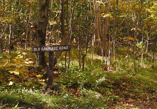
For years, the sign “Old Carriage Road” marked an overgrown length of abandoned roadbed halfway up the road to the summit of Mount Philo State Park. It’s an evocative spot, triggering visions of Victorian-era carriages where there are now maple and beech. But two years ago, without explanation, the sign was relocated to a footpath a half-mile farther up the road. Had new evidence been found? Was I no longer to consider the abandoned roadbed part of the old carriage road? I walk the summit road almost daily and (full disclosure) am fairly besotted with the park. So before confronting park staff with emotion-laden questions, I decided to do some research.
Thus began my obsession with tracing the route – the entire route, from the bottom of the mountain to the top – of the old carriage road.
Mt. Philo is one of a series of klippes, erosional remnants of the leading edge of the Champlain thrust fault, that run north-south along Vermont’s Champlain Valley. At 968 feet, it is more hill than mount, and its forested slopes rise out of what was once entirely agricultural land but is now – 15 miles south of Burlington – increasingly developed. The one-way loop road, open to cars in summer and fall, is 1.5 miles up and one mile down. Vast and rugged wilderness it is not. But the summit rocks offer unequaled views of the Champlain Valley, Lake Champlain, and the Adirondack Mountains. Sunsets are spectacular. During hawk migration, birders crowd the overlooks; in winter, the unplowed road teems with kids and sleds. Year-round, there are many, like me, who ascend the road regularly, seeking exercise amid the quiet woods. Small (just 237 acres) and tame as the park may be, it is a place that instills deep feelings.
I began my search for the old carriage road, nearly two years ago, by scouring the park’s detailed National Register for Historic Places nomination papers. The bibliography sent me to the state archives, the University of Vermont’s Special Collections, local libraries, town clerks’ offices, historical societies, and the Vermont Department of Forests, Parks and Recreation files. The clues I found – some by serendipity – were in old maps, early picture postcards, Vermont State Forester reports, tourist brochures, the nomination papers themselves, and – sweetest of all – a poem, “Mt. Philo Picnic,” narrating in rhyme an early twentieth century ascent.
A grander path one seldom finds
With trees and ferns on either side.
Western View is a wonderful spot
When once you’ve reached it the climb’s forgot.
Each new clue sent me tearing up the mountain with text, map, or photo in hand to search the woods or take a new look at some boulder or tree, hoping to match what was on paper with what is there now, despite the effects of 100 years of reforestation, park construction, and storms. It was a treasure hunt, and like all good treasure hunts it became addictive.

The Old Maple: Deforestation
A postcard from the early twentieth century, found in a collection at UVM, shows the mountain’s west flank soon after the carriage road was built. The lower half of the road is entirely visible, switchbacking through open fields that today are completely forested. Seeing that much of the road exposed was exciting, but over time the photo proved remarkably frustrating. Without discernible landmarks connecting the cleared slope in the photo with today’s forested one, I had no way of knowing how – or even whether – the old road’s switchbacks matched those of today.
Until, during one of my daily walks, I stopped about a quarter of a mile up the park road to consider a tree, a magnificent, wide-spreading maple tucked within the woods. I looked at the old photograph – at one particular isolated tree within a bit of fencing in the field – and I looked at the tree in front of me. Everything matched: the old maple’s size made it the right age; its shape spoke of time in the open; its distance from the road was right, as was its relationship to a line of equally spaced trees that were saplings in the photo.
Suddenly the maple, which I’d walked past hundreds of times, became a bearing, a point by which to determine the carriage road’s lower route. With a few other clues, it enabled me to trace the old road’s path (much of it coinciding with the current road) from its start to midway up the mountain – to where the length of abandoned (and now unsigned) roadbed begins.
But the tree did something else: it enabled me to see today’s wooded slope as pasture, not only as it was in the early twentieth century, when the photo was taken, but 70 years prior, in the mid-1800s, when the entire mountain was cleared, the “noble pines converted into boards and shingles,” as described in a 1910 Vermonter article by Samuel Bassett.
There are astounding statistics from this part of New England’s history: the land cleared by European settlers for building material, potash, and firewood in the late 1700s and early 1800s, the rise of sheep farming in the mid-1800s, and the resulting deforestation of 75 percent of New England. According to Ellen Stroud, in Nature Next Door, in 1840, at the height of “sheep fever,” there were 1.7 million sheep grazing in Vermont and over 600,000 in New Hampshire.
These are difficult numbers to fathom. Yet, standing in the woods with the old photo, seeing the maple in both its young and old guises, I could envision that slope as field; I could envision the 200 sheep owned by James Palmer, the 74 owned by John Palmer, the 60 owned by Jones-Smith – listings in an 1843 tax book for the farms that then comprised Mt. Philo – grazing there.
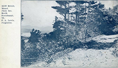
The Iron Railing: Field and Forest
Another postcard, captioned, “New Road, Mount Philo Inn...F.A. Lewis, Proprietor,” shows a stretch of dirt road passing by a high, distant view of Lake Champlain before heading into the woods. At first glance, it resembled other photos taken from the carriage road, all maddeningly impossible to locate. But in the lower left corner of this shot, below the view, was a length of iron railing that I thought I recognized. I was pretty sure it was the railing at the southern outlook, a secluded viewpoint off a footpath along the summit ridge – a favorite spot of mine for its quiet and the air of elegance lent by the railing. If the railing in the photo proved to be that at the outlook, then I’d have a sure location for at least some of the old road’s route at the top.
Crouched within the trees that now crowd the outlook, I angled the photo this way and that, determined to make its railing, road bed, and lake view line up with those before me, fully aware of just how much I needed things to match. And eventually, miraculously, even objectively, they did. The “New Road” in the photo and the footpath to my right were one and the same. The railing at the southern outlook, installed by F.A. Lewis along with the carriage road, provided evidence of at least this small stretch of the summit route.
And, like the old maple, it took me back in time.
Frank A. Lewis bought the Jones-Smith farm on the west side of Mt. Philo in 1887, a good 40 years after sheep fever had ended and farms in Vermont were struggling to survive. Frank and his wife Clara farmed the land, but also turned the farm into a summer tourist destination, offering, as advertised in their brochure, “a delightful retreat from the heat and turmoil of the city,” promoting the healthful benefits of “the best of fresh country fare, butter, eggs, milk, and vegetables fresh from our own farm.” They razed the farmhouse, built an inn, and established a colony of canvas tents for guests wanting a more rustic experience.

Inn guests James and Frances Humphreys, of Dorchester, Massachusetts, first came in 1900 and grew so enamored of the place that they began buying much of the farmland on the mountain, built a summer home at its base, and urged the Lewises to build a carriage road for guests. In 1902, the road was complete, as were roadside gazebos, foot trails, benches, overlooks, and a summit observation tower. “The mountain road,” reads the inn brochure, “threading its way through open fields and woods affords a variety and intensity of scenic beauty seldom equaled in New England.”
The mountain, which 50 years prior had been cleared of trees and grazed by sheep, was now pasture on much of its lower half and forest on its upper: the epitome of the bucolic landscape being encouraged statewide as a lure for tourists. While other northern states were wooing urban vacationers with rugged wilderness, Vermont was offering the pastoral life, with easy access to nature. “Everything possible is done to make the way safe as well as agreeable,” Bassett quotes James Humphreys as saying about the carriage road. “All precipitous places are boarded by neatly painted iron railings, and at short intervals resting places are provided.”
Trees had been allowed to return to the upper half of Mt. Philo, and many other places in the Northeast, not only because sheep farming had ended, but because the effects of near-total deforestation of the mid-nineteenth century had triggered a regionwide (in fact, nationwide) conservation movement. Soil, water quality, and scenery had all suffered as a result of what Vermont Governor Woodbury called in 1894, “the wanton destruction of our forests.” In response to this burgeoning awareness, forestry commissions were established at both federal and state levels (New Hampshire, 1881; Maine, 1892; Vermont, 1892; and the USDA’s Division of Forestry, 1881), as were forestry schools (Cornell, 1898; Yale, 1900). Conservation legislation such as the Weeks Act of 1911 was passed on both federal and state levels, enabling the government to purchase and set aside land for preservation, management, and public use.
It was a movement not lost on Frances Humphreys. When asked in 1918, a few years after her husband died, when she planned to cut the trees that had regrown on Mt. Philo, she said she would cut, “not a stick of it...I dislike to see the mountain changed. There is something in the world besides money, good as that may be.” And in 1924, again acting in concert with the times, she donated nearly all of her land to the state, “for the health, recreation, and pleasure of the public,” establishing Vermont’s first state park.
The important role Northeastern urbanites played in the early conservation movement is well documented in Stroud’s Nature Next Door: how they came north in the summer to escape the city, saw the vital need for undeveloped, forested land, and acted to preserve it, lobbying for conservation legislation, sometimes buying and donating large tracts themselves. The swaths of Northeastern land conserved during this period – areas that eventually became the White Mountain and Green Mountain National Forests, as well as the Adirondack Park – are on a scale difficult to fathom today.
Yet it wasn’t regional conservation that motivated James and Frances Humphreys, it was simple love for one very small mountain – something I could well comprehend. For the “sense of close companionship with the forest” that James Humphreys sought on Mt. Philo every summer was exactly what I came for every day; the view he sought most mornings (according to a contemporary, “the sunrise often finds him on the summit”) was the very same view I sought most afternoons. Standing at the outlook, iron railing in my hands, I didn’t so much understand this aspect of the past as make direct contact with it.

The Concrete Block: Reforestation
And what about the stretch of abandoned roadbed that had started my search? Was there evidence of it being part of the old carriage road, a middle section that would connect the lower half with the bit I found near the summit?
On the other side of the paved road from the abandoned roadbed, easily missed for the surrounding trees, is a crumbling concrete block – roughly four feet square with a round, shallow depression in its top – whose age and purpose had long mystified me. There’s no mention of it in the National Register papers. There’s nothing else like it in the park. Its only apparent connection to anything else is that one end of the abandoned roadbed points directly at it. But that could well have been coincidence; the block might have been a modern artifact having nothing to do with my search.

Yet, staring for the umpteenth time at an old postcard of one of the roadside gazebos, I suddenly realized I was looking at the concrete block. It was inside the gazebo. Zooming in, I saw that the block was encircled by benches. Running up its east side was a pipe that turned 90-degrees to overhang the top depression and fill it with water. The concrete block must have been a basin, fed by a nearby spring. I wondered if I’d found the site of Well Spring Shelter, one of several roadside gazebos named, in ascending order, by Frances Humphreys in her poem, “Mt. Philo Picnic.”
We now arrive at Well Spring Shelter,
A better name t’would be hard to venture.
For here is water for man and beast,
And all the surroundings are most complete.
If it was Well Spring, then I had evidence (concrete evidence) that the abandoned roadbed was indeed part of the old carriage road, for in the photo, the road swings right by Well Spring Shelter. It points, in fact, directly at it.
Poem and photo in hand, I examined the concrete block like never before. Running up the center of its east side was a stain – ghostly faint – the width of a narrow pipe, and on the south side of the depression, so deeply embedded I had to lean over to see it – was a piece of pipe that ran through the block, turned, and led away at ground level. This must have been the outflow. Standing on the abandoned roadbed facing the concrete block, I saw, through the maples and beeches, how it had once continued on its path to swing by the site of the shelter. It all made sense.
Yet it also didn’t make any sense. In the photo, the view from the gazebo was wide open to the lake and Adirondacks; today, there is no view whatsoever. The landscape in the photo and the existing site were so absurdly different, I couldn’t believe it – even after checking and rechecking the photo’s evidence. If ever there were a place to underscore the dramatic changes of reforestation, this was it.
Looking more closely, I noticed that the species immediately surrounding the concrete block and growing in the old roadbed were native, but those a bit farther away – in fact, most of the trees blocking the view – were Norway spruce, non-natives that wouldn’t have simply sprung up. They had been planted. I realized I was looking at 78-year-old survivors from the spring of 1935, when 3,000 three-year-old Norway spruces were planted by the Civilian Conservation Corps, along with 3,000 white pines, and 2,000 red pines, as listed in the 1936 biennial report of the State Forester. There were earlier plantings done by the state, as well: 42,000 Scotch pines and 5,000 jack pines in 1925 (soon after Mrs. Humphreys made her gift), and 16,200 European larch in 1929, many of which are still alive, despite severe damage to the stands during the ’98 ice storm.
Plantations such as these were being established all over the Northeast in the first decades of the twentieth century as part of the attempt to make up for – and prevent repetition of – the devastating effects of the previous century’s deforestation. Ellen Stroud writes, “while Vermont was behind other states in replanting efforts and forestry expenditures – New York led the region, and Connecticut and New Hampshire both distributed far more trees as well – the challenge was the same throughout the Northeast.” Erosion and flood control, protection of water quality, and the managed production of timber were the primary goals. Stroud quotes Vermont’s first state forester, Austin Hawes, who, in 1910, wanted “Vermonters to ‘consider the forest as an agricultural crop to be harvested, reseeded, improved, and reaped again; instead of a mine to be exploited and abandoned.’”
Hawes predicted that while water quality and timber production were the impetus for reforestation, “its value in preserving the beauty of the State’s scenery is not to be overlooked, and this will undoubtedly be more of a commercial asset of the State in the future than it has been in the past.”
So it was for a variety of reasons – economic, ecological, and aesthetic – that plantings such as those on Mt. Philo in the 1920s and 1930s were being conducted on both private and newly acquired public lands through the Northeast. “The return of forest,” Stroud writes, “....is not merely the result of benign neglect, allowing forests to establish themselves wherever they were no longer beaten back to make space for fields. Trees came back because time and ecology gave them favor, but they were also encouraged and protected by choice.”
In his introduction to Stroud’s book, William Cronon makes it clear why understanding this is so important. “It would be foolish indeed to believe that if we simply adopted a hands-off attitude toward such matters, nonhuman nature on its own would yield the results we desire...The [American Northeast] has forests today because people made choices about them and then did the hard practical and political work of making those choices real. Such things do not happen by accident. They happen because people make them happen. That is as true today as it was a hundred years ago.”
The reforestation of 75 percent of New England over the past 100 years is another of those statistics I can barely fathom. But I can see, in an abandoned concrete basin, one woman’s choice to donate much-cherished land to the state for its preservation; I can see, in the maples and beeches that have taken over an old roadbed, the effects of “time and ecology;” and I can see, in a grove of view-obscuring Norway spruce, the choices and investments made by the state of Vermont and its foresters, as well as the efforts of a band of young men wielding shovels and seedlings. Every day I walk by these things, I am reminded that this small pocket of forest I love is not here by accident.
In the end, I’m almost certain that the route of the old road ran from the bottom of the mountain, past the grand old maple, alongside Well Spring Shelter, to the old iron railing. Beyond this point, repeated construction over the past 80 plus years at the top of the mountain and a dearth of photographic evidence make the route around the summit no more than conjecture. I’m not disappointed, though, for in my search I gained invaluable lessons in history on a visceral level. Indeed, if there’s one thing I learned in my search for the old carriage road (aside from most of its route) it’s that reading about the past and understanding it actually happened are two different things.
I brought my findings to the Vermont Department of Forests and Parks, with a request that the Old Carriage Road sign – relocated by mistake, it turns out, by an all-new staff that year – be returned to its original spot. The information was received enthusiastically and spurred talk of doing some historic preservation in the park. And though my obsession with the old road has abated considerably, I suspect that my walks on Mt. Philo will forever be haunted.