
Aimee Kidder hiked up a small rise and down into a dip in the forest floor. Then again, up and down across another dip. Aimee, an eighth-grader at Hartford Memorial Middle School in White River Junction, Vermont, and her classmates were searching the Hurricane Town Forest and Wildlife Refuge Park, not far from their school, for distinctive forest features as part of the Vermont Institute of Natural Science’s Community Mapping program.
Ben Musson and two other students selected a slab of exposed roots from some tipped-over trees as their distinctive feature. Nearby, other kids chose a towering, seven-foot wall of roots from a toppled hemlock. Farther west, yet another group picked a grove of trees with oddly kinked trunks, which one young woman described as looking “like a cat’s foot.”
Clearly, some mystery was afoot. But while the thoughts of the young woman among the cat’s-foot trees turned to something supernatural from The Blair Witch Project, the explanation for the weird landscape was more natural and closer at hand.
“A hurricane came through here,” said Ben.
How did he know? The students were making connections between the name of the forest and an actual hurricane with the help of their teachers and Tom Wessels’ book, Reading the Forested Landscape.
The book paints the scene of the devastating hurricane of September 21, 1938, that swept north up the Connecticut River valley before arcing west across Vermont. A quarter million acres of forest were leveled. The storm left its mark of weird trees and walls of exposed roots on Hurricane Hill in Hartford, in the nearby town forest and refuge, and all across New Hampshire and Vermont.
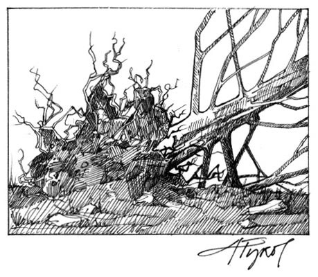
Wessels explains that toppled trees often leave behind clues to explain what toppled them. Recognize the clues and you can figure out why the tree fell. A suspicious number of the trees in the Hurricane Town Forest were felled with their tops pointing toward the northwest – the distinctive calling card of the Hurricane of ’38.
In your average forest, trees fall every which way. That’s because a long-dead standing tree can be toppled by a strong wind from any direction, says Wessels. The clue that the tree was dead before it toppled is that decayed roots don’t bring up much soil as they go over. A fallen dead tree tends to lie atop ground that is relatively undisturbed.
The chapter on the 1938 hurricane in Wessels’ book is called “Pillows and Cradles.” The title refers to the pit and mound landscape that develops in a forest after a large number of trees have been blown down while they were still living, such as after a hurricane. Unlike dead trees, live trees bring up a lot of earth with their roots when they go over. This divot of earth creates a “pit” or “cradle.” Wessels calls it a cradle because the bare earth becomes a good place for small-seeded trees such as birches, aspens and pines to sprout and grow. As the fallen tree rots, the earth in its roots drops into a pile, creating the corresponding “mound” or “pillow.”
Strong blasts of air from summer thunderstorms also blow down live trees, not just dead ones. Since these storms usually arrive from the west, their winds leave tree trunks pointing from the northeast through the southeast. Find the average direction, says Wessels, and you’ll see it is due east. Fallen trees with their tops pointing east is a strong sign, therefore, that they were blown down in a spring or summer thunderstorm.
Winter gales are also strong enough to knock over live trees. Wessels says that trees that fall toward the southeast and south usually have been felled by the arctic blasts of a fall or winter gale, whose strongest winds are usually out of the north and northwest.
Hurricane winds are complicated. They blow counterclockwise around the storm’s eye, meaning that the direction a hurricane-blown tree falls depends on where it was in relation to the path of the storm. Wessels says trees that have fallen to the northwest are a clear sign of a hurricane, both because other storms won’t fell a tree in that direction and because that was the direction of the blowdowns all across the Connecticut River valley from the 1938 hurricane.
As Aimee Kidder hiked up and down and up and down one day in the Hurricane Town Forest and Wildlife Refuge Park, something clicked. “Pillows and cradles,” she thought, as she realized what she was walking over. Tree trunks pointing northwest. The Hurricane of ’38. Mystery solved.