Perhaps the first thing that can be said about the winter sky is that, relatively speaking, it’s pretty boring. Discounting the occasional sun dog or freak crack of lightning in the heart of a blizzard, there’s not much to see. Even a heavy snowstorm poised to drop feet of snow tends to creep in on sheets of gray clouds that thicken imperceptibly.
This is because the typical winter sky is frozen. All the moisture between the ground and the tropopause (the top of the weather-producing layer of the atmosphere) is locked up as ice. Unlike water vapor, which gives clouds a sharp and definite outline (think of a growing thunderhead), ice crystals usually produce a vague and indistinct cloud edge. On top of that, icy clouds slide in from elsewhere, far less dramatically than the towering cumulus of summer that grow before your eyes.
In the general case, the warmest air in winter is at ground level, where the sun heats the earth and the earth heats the air just above it. It gets steadily colder from there, right up to the tropopause, so if it’s 10 below where you’re standing, you can imagine how much colder it is farther up.
In the case of the South Pole, much, much colder. I have a meteorologist friend who spent a season at the Pole during the sunless Antarctic winter. On a regular basis, he would launch weather balloons into the sky that would radio data back to the observatory as the balloons rose through the troposphere. The dark sky was so uniform and windless, with the temperature steadily dropping with altitude, that when the balloons finally popped and the instruments crashed back to earth, they would sometimes land within 100 yards of where they had been launched hours earlier.
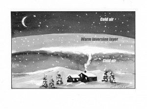
We would have the same uniform conditions here in Vermont and New Hampshire – no weather to speak of – except that we also have daylight, short though it may be. During the day, the sun heats the ground and the ground heats the air. At night, when the sun’s energy is removed, colder air aloft sinks toward the ground and replaces the warmer air near the surface. This lead to the inverse of the “it gets colder as you go up” rule, and is aptly named an “inversion.”
Inversions are common winter events, especially on clear nights when the air has plenty of opportunity to cool and sink. Sometimes these inversions can be very local affairs – think of the woodsmoke that seems to reach an invisible ceiling a few dozen feet above the chimney and spread sideways. The cooling woodsmoke has reached a layer of air that is warmer than it is (perhaps from the sunny day before) and lost its upward mobility.
Inversions can be regional affairs that cover entire valleys or states. Winter climbers in the Green and White Mountains – especially those inclined to get an early start on a frosty morning – may find that the snow-capped peaks look like islands poking up out of a sea of thicker air. The overnight inversion has trapped the dust, debris, and pollution down near ground level. This phenomenon can be especially pronounced in western cities like Salt Lake City and Denver, where nights tend to be clear and where high mountains block the wind, allowing inversions to remain in place for weeks at a time.
In our case, winter inversions rarely last very long before a new weather front sweeps in to re-mix the atmosphere. A warm front, when warm air from elsewhere slides in over the colder air near the ground, is also a time when the “it gets colder as you go up” rule is turned on its head. If the cloud edges look blurred and indistinct, the front may be “warm” to us but is still cold enough that all the moisture is frozen. Get ready for snow.
When the clouds look sharp-edged and cottony, however, liquid water is on the way. If there’s enough cold air between the clouds and the ground, the falling moisture may crystallize into snow – perhaps heavy snow. But if the clouds are low and the cold layer thin, prepare yourself for the most depressing of winter phenomena: freezing rain. Or just rain altogether.
Last March, I saw a winter sky that caused me to double-take. The field where I was walking was covered in snow, the day was cold, and everything from the trees down looked like mid-winter. But overhead, a warm front was rafting in a lovely, summery scene of puffy cumulus clouds, looking for all the world like mid-June. After the boring skies of winter, it was a sight I wasn’t sorry to see. I would have taken a photograph, but in this day of digital manipulation, it would have looked fake.