Have you ever wondered what your property looks like from above? Or how it fits in with your neighbors’ properties? Topographic maps and property surveys can give you an abstract understanding of your boundary lines, terrain, and vegetation mix. But for a really clear picture, nothing beats – well – a picture. More specifically, a picture from above, otherwise known as an aerial photo.
Aerial photos are often available for free on the internet, from sites such as Google Earth (see list below). They can also be bought for a small fee from many companies; these photos are usually rectified (matched with map coordinates to get rid of photo distortions), and you can purchase them with layers – from parcel boundaries to topographic lines – applied on top of the bare photo. Rectified photos are also known as orthophotos.
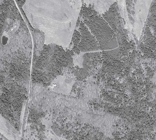
Besides providing a new perspective on your home, aerial photos are one of the most useful tools you can use for getting to know your property. You can use them to locate property features, such as old woods roads, stone walls, streams, wetlands, orchards, conifers, hardwoods, and clearings, and to assess the relative size and composition of your woodlands.
Since they’re usually taken from planes in the fall or spring, when the leaves are off the trees, it’s easy to tell the dark, dense softwoods from the light, bare hardwoods. You can also get a sense of the size and density of your trees. The geometrical shapes of roads, pastures, and managed forest stands are obvious. And you may discover features on your property of which you were previously unaware; for instance, if you look very carefully, you may discover lines of slightly older trees that indicate the presence of an abandoned road that isn’t obvious at ground level.
Whether you’re completely new to your property or have been walking it for years, aerial photos will likely teach you something new or give you a fresh perspective. New property owners may want to obtain an aerial photo and add to it features such as property boundaries, buildings, and topography in order to begin familiarizing themselves with their land. As you walk your woods and get to know individual trees, cellar holes, vernal pools, deer trails, and so on, you can draw those features on your underlying photo. In doing so you’ll get a sense of how your property has evolved over time, how it is used by wildlife, and how it fits into the larger landscape.
You can find U.S. Geological Survey aerial photographs at some college library mapping facilities, university extension offices, soil and water conservation districts, or even through your forester. Some places can print you out a large-format photo, usually for a small fee. And companies such as Garmin and DeLorme have aerial photo products that will work with your GPS receiver or PDA. Orthophotos are also available on many websites. Some allow you to print clear photos, while others allow printing of low-resolution previews or watermarked images only, requiring you to purchase their printouts. Several have tools that allow you to layer topographic, road, and other information layers on top of the raw photo. Sites include:
Microsoft TerraServer
Google Earth
Digital Grove
MapMart
Maptech MapServer
Terrafly
GlobeXplorer
HistoricAerials