
The canoe scraped noisily onto the gravel bar on the point of one of the great bends in the northern Connecticut River. I’ve stopped to see a remnant of the floodplain forest that once covered several thousand acres along this stretch of river. It was a rich and diverse place, the flood-tolerant suite of plant life fed by seasonal high water and the fertile sediment it carried downstream. Today, conservationists are working to restore floodplain forests, but the most effective restoration techniques are provided by Mother Nature. We would do well to pay close attention.
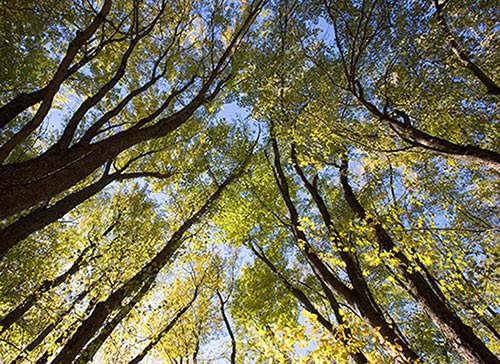
The forest on the point where my canoe is beached is diminutive, but instructive nonetheless. I pick my way over the gravel and through a thicket of red-stemmed dogwood and shrub willow, with silver maple seedlings poking their way toward the sunlight. As the shade deepens, the shrubs disappear and I’m in a belt of older trees. Continuing away from the river, I part the giant fronds of shoulder-high ostrich fern and enter the cathedral formed by towering silver maples. I can’t help stopping to crane my neck upwards. The trees must be at least 75 feet tall and more than 20 inches in diameter. Their crowns arch far overhead, forming a shaded space that seems to stay cool on even the hottest days. Looking down between the ostrich ferns, I see the latest deposit of sediment from the floods that happen at least once – often three or four times – each year. I emerge into a small opening, where wood nettle covers the ground. Like the ferns, the nettles grow tall here, nourished by the rich, moist soil. Nearby are several young silver maple saplings and the broken stub of a large tree. I deduce that several years ago, the large tree snapped off – probably in a thunderstorm – crashing to the ground and leaving an opening in the canopy. Since then, those neighboring trees have raced to fill the opening, so only a small circle of blue sky is visible today.
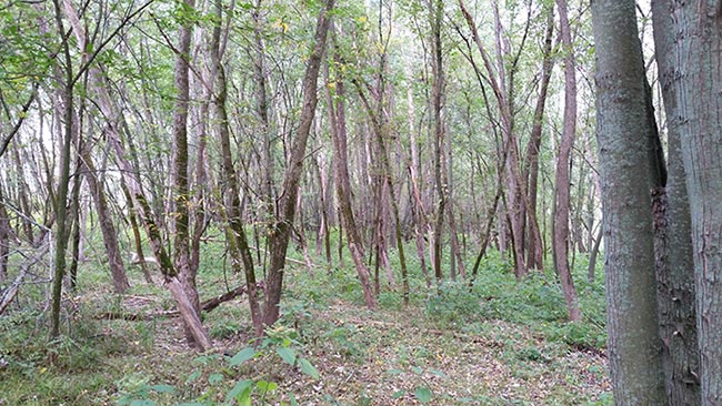
Floodplain forests nearly disappeared along the Connecticut River in the decades following European settlement, but the trend has now reversed, at least in the headwaters reach of the river between Essex County, Vermont, and Coos County, New Hampshire. We will never see the forest that met the first settlers, but silver and red maple, box elder, cottonwood, elm, willow, alder, wild grape, ostrich fern, sensitive fern, and other plants adapted to this dynamic environment are steadily reclaiming their place in the valley.

The resurgence of floodplain forests here is driven by three factors. The most important is the changing agricultural practices of the last 30 years. Until the 1960s, the Connecticut River valley was lined with small dairy farms. Their buildings were perched on the terraces that flank the floodplains, and their fields stretched down to the riverbank. The best and driest soils on floodplains are found right along the riverbank, and trees were cleared to make maximum use of those areas. Back away from the river, the old oxbow wetlands were seen as a nuisance and drained. In between the best fields and the wetlands were marginal soils that the farmers used for pasture. Those areas had wet dips and dry ridges, almost like waves, reflecting the typical deposition patterns of floodwater making its way through a floodplain forest. Tractors got stuck in the wet spots, and the dry spots were too small to crop, so farmers let the cows do the harvesting. The alders and willows that tried to recolonize their domain were persistently cleared away to let the grass grow. Likewise, the edges of the rectangular fields were kept trimmed back to the fence line or the riverbank. Small farms needed every bit of their land to be productive, and farmers somehow had the time to keep all their field edges trimmed.
Today, farming is different. There are still many cows in the valley, but most are in barns on a few large farms where their feed is rich and controlled. Even the smaller farms stopped pasturing, often due to the scourge of a resurgent population of moose, which have no problem walking through any sort of fence – sometimes carrying hundreds of feet of wire across the landscape. Equipment got bigger and bigger, requiring a wider turning radius at the corners of fields. Farmers no longer took the time to trim back the edges, and with no cows pasturing the marginal areas, hedgerows began to grow up again.
The Johnson farm, in Canaan and Lemington, Vermont, is a great example of this process. The farm had grown over the years as it absorbed smaller farms, and by 2010, it encompassed over 1,000 acres. Aerial photos from 1955 show that nearly all that land was actively farmed and pastured. The only exceptions were the wettest of the old oxbows that flank the river. Over the last 30 years, old drainage ditches were abandoned, cows were removed from pasture, and cropland was restricted to the best acres. To say that this part of the valley between Canaan and Colebrook is frequently flooded is an understatement. As the snow melts from the cold, rugged hills that form the headwaters, the valley is flooded each spring. A canoeist in midsummer would find it hard to imagine that in April or May the water would have been 10 feet over her head. After the first flood, with the receding water leaving its coating of rich-smelling sediment, farmers begin their spring work. Often, however, a second flood occurs in late May or early June. There are years when a third or fourth flood occurs in midsummer, brought on by hard rains.
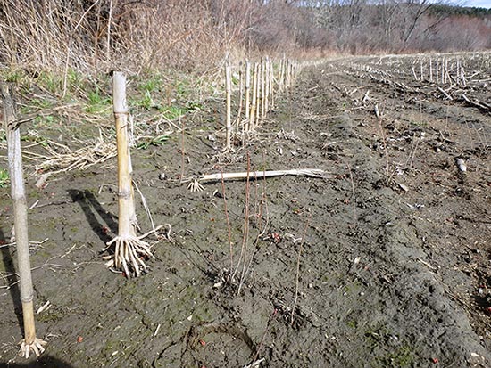
Young corn plants cannot survive a long submergence, but silver maple and its sister floodplain plants thrive in such an environment. In 2005 and 2006, the Johnsons recognized the inevitable and enrolled in the Conservation Reserve Enhancement Program (CREP), planting thousands of trees along four miles of their farm’s riverbank. Thanks to the Johnsons’ generosity, most of the farm has now been conserved, and much of it forms the new Johnson Farm Wildlife Management Area. Trees continue to be planted, but the real restoration lies in the natural regeneration of the species best adapted to floodplains. Large silver maples that survived along the bank scatter seeds with abandon, as they have done since reaching maturity. To germinate and grow, a seed must land on bare soil, whether that is flood sediment deposited in a willow thicket or a cornfield kept bare with tillage and herbicides. Before the conservation efforts, the thousands of tree seedlings that sprang up each year in the cornfields were cut out, trampled by cows, or plowed under. Now, those seedlings can sprout and grow undisturbed. On the Johnson farm, in the two small pieces of floodplain where cornfields were turned into buffer 12 years ago, the trees that were planted by conservationists are now crowded out by dense trees grown from seeds that simply landed on bare soil.
Another reason for the return of the floodplain forest here is the very nature of these 85 miles of the Connecticut River. It is the only significant stretch of free-flowing water in the entire 450 miles of New England’s greatest stream. The gravel bar on the point where I’ve landed is a testament to the dynamics of this river. For gravel bars to form in the channel of a flowing river, there must be a supply of sediment that is greater than the capacity of the river to carry it away. The major sources of sediment are eroding banks. As the soil melts away on the outside bank, thus widening the river channel, sediment is deposited in the slower water of the inside of the bend, and gravel bars form. These bars are the foundation of a new floodplain. This give and take of sediment is the nature of riverine floodplains. These areas serve to store sediment – but only for a time, until the river can carry it on downstream. As gravel bars grow out into the channel, Mother Nature begins to fill the vegetative void. This is raw, brand-new alluvial soil, and seeds quickly discover it. The willows and dogwoods that are present along the edge spread out into the newly deposited land. Even when bent over by ice or buried by sediment, these species are well adapted and have no trouble surviving. Stems that encounter moist soil sprout roots and extend their reach. Meanwhile, each flood brings new sediment that settles easily into the dense shrubbery. In turn, silver maple seeds find that moist bed of new soil, germinate, and begin their upward journey toward sunlight. The trees grow and begin shading the shrubs. The shrubs continue to expand outward into the sun, trap more sediment, and host new seedlings. Flood by flood, this cycle continues, and floodplain forest becomes established in an orderly progression of age classes, with the youngest trees along the outside.
Another reason for the recovery of floodplain forest is simply our recognition of its importance. When I was hired by the Soil Conservation Service (SCS) in 1978, the agency was focused on agricultural production, which reflected the dominant thinking of the time. Allowing floodplain forests to form and to grow up was considered wasteful, because it took away from “productive” agricultural acreage. We helped farmers improve drainage ditches and grade the typical undulating meadows of an active floodplain. When the riverbank eroded, we stepped in with riprap to stop it and cut trees that might uproot and destabilize the bank.
Today, the SCS has become the Natural Resources Conservation Service (NRCS), and the agency is much more cognizant of the broader ecology of floodplains. Other groups – notably including The Nature Conservancy – have stepped up to study the complex interactions of the organisms that form the floodplain forest ecosystem.
Riverbank erosion is now recognized as a natural process of sediment transport. Deposition of that sediment is known to be vital to the natural regeneration of floodplain forest species. Trees are left to grow and fall where they may. We are slowly realizing that all man has to do is get out of the way, and Mother Nature will work her magic.