
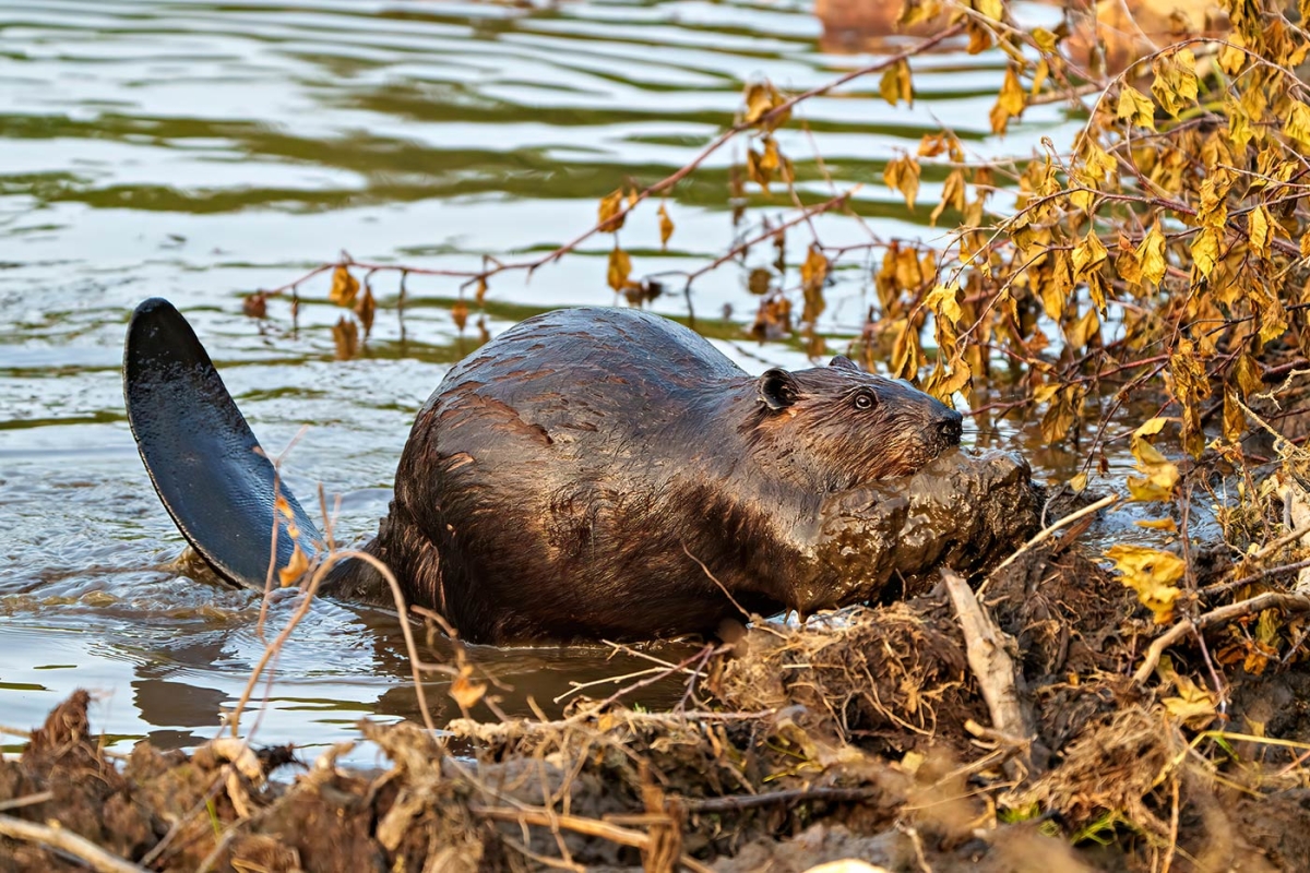
Open a hydrology map of a northeastern watershed, and you’ll see networks of blue lines: delicate threads of headwater streams starting high in the mountains, crossing contours to merge with each other, and flowing into larger streams and rivers that wind through low valleys. If we could conjure a map of the same area from several centuries ago, it would be full of sprawling blobs of wetlands, the stream lines connecting them like a tangled string in a beaded necklace. These wetlands largely emerged from the work of beavers.
Prior to the European fur trade and settlement of North America, beavers inhabited far more terrain than they do today. The densely wooded landscape was wetter, and there was more habitat variation at the local scale. Water moved more slowly. A drop of rain falling high in an upland forest might have traveled through hundreds of meticulously maintained beaver dams on its slow roll to the ocean. Dams created the wetland conditions needed to grow beavers’ food, as well as the watery environments that protected their lodges and allowed easy aquatic travel.
Trappers largely extirpated beavers from the Northeast beginning in the 1600s, and the settlers who followed cleared forests, drained wetlands, and established roads and settlements in valleys that had recently lost their keystone mammal. These activities degraded how watersheds functioned. Water tables dropped, and wetland habitats disappeared. Streams that had once moved dynamically across their valleys – shifting their paths and floodplains over time and redistributing gravel, fallen trees, and other materials – became channelized. Storms washed centuries of rich soil into waterways and carved dramatic gullies.
Today, beavers are returning to this landscape – thanks in large part to a reintroduction program by the state of New York in the early twentieth century – but our watersheds still retain the degraded legacy of the past three centuries. Stream channels are deeply cut, reinforced with stone, and confined; wetlands are a shadow of their former presence; and although forests have regrown in many old farm fields, watersheds lack the density of wood – both living and dead – that once characterized them.
As an ecological restoration practitioner, I value how returning beavers have restored wetland and riparian systems. Beaver dams impound water, saturating land and spurring the re-establishment of wetland natural communities, including floodplain forests, marshes, peatlands, and swamps. These wetland complexes retain sediment and nutrients, reduce erosion and downstream flooding, and support vibrant, diverse, connected populations of plants, insects, birds, mammals, fungi, and microorganisms that filter and clean water.
Yet beavers’ reintroduction is not complete, and in many places it cannot be, given the context of our settled landscape. There are places beavers cannot yet coexist with modern land uses, although innovations including beaver flow devices can reduce conflicts such as road washouts. In other places, centuries of settlement mean there isn’t a critical mass of beaver food or wood for dam and lodge building. Other areas just may not be attractive to beavers. In these sites, the human restoration community can learn from Castor canadensis, imitating beaver techniques as part of a set of restoration methods to improve stream and wetland function and to attract beavers when appropriate. With careful planning and the right permits, these methods are inexpensive, easy to learn, and can be accessible for a wide range of people. We are using them to bring those blue blobs, and their watershed benefits, back to the map.
Beaver dam analogs (BDAs) are simply structures built by humans to replicate key features of actual beaver dams. This technique functions along with other process-based (as opposed to form-based) restoration methods – such as strategic wood addition, engineered log jams, and live stake and fascine installation – to bring woody structure back to streams in targeted ways. BDAs may be used to attract beavers to a site, or they may be employed to restore or improve wetlands at sites inappropriate for beavers. BDAs offer a relatively new approach to watershed restoration, and I’ve enjoyed implementing them as part of my work with the Vermont Land Trust (VLT) and in collaboration with other organizations.
Learning from Beavers
For two years, I’ve been observing beaver activity at a restoration site on VLT-conserved land along the Winooski River. Each fall during a dry spell, beavers dam an entering tributary near the river confluence. Their dam is doomed, because any sizeable rainstorm or seasonal melt will swell the confluence area up to 10 feet above it. But watching the beavers gives me a chance to see how they work from the ground up.
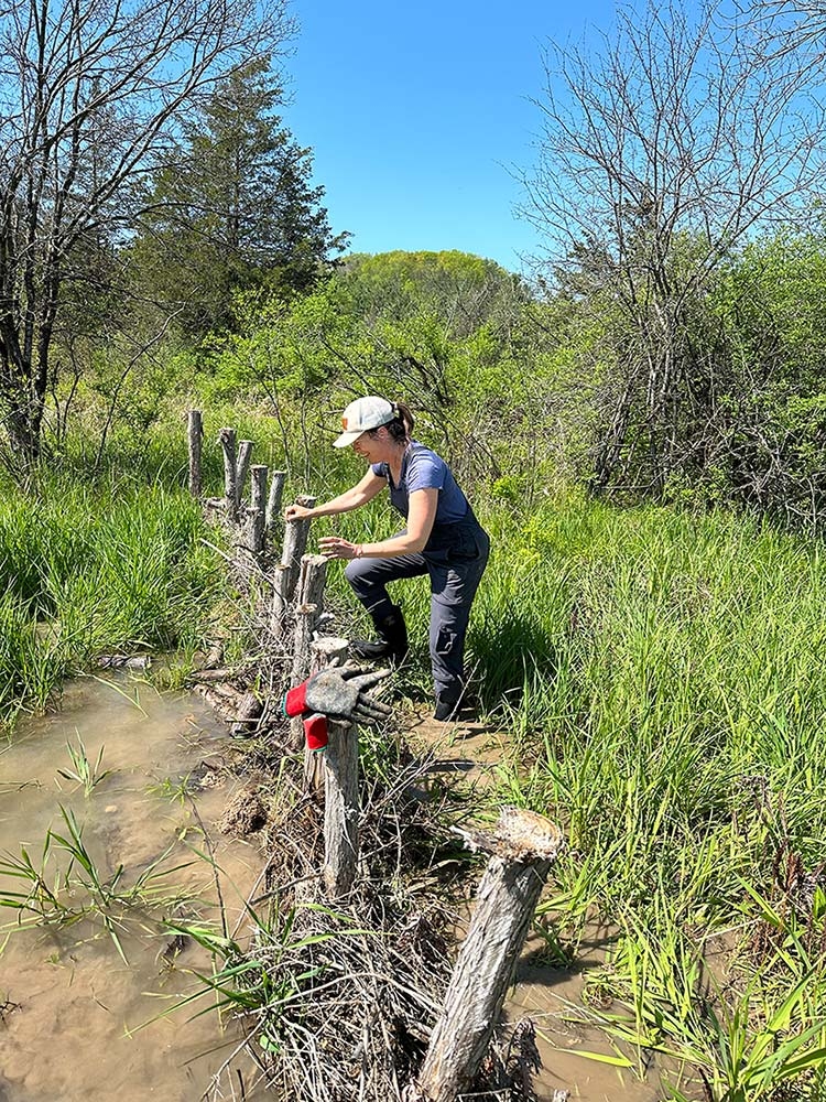
The beavers selectively coppice willows from a floodplain bench upstream, taking a few stems from each plant. They drag these, as well as boxelder and poplar pieces, to the most constricted part of the floodplain: by a pile of rocks a previous landowner placed to stabilize the now-abandoned field. This site allows the beavers to tie in to the more stable feature and to build a shorter dam. They lay larger gnawed pieces onto the sandy streambed, perpendicular to the flow, and wedge other stems around these, creating a dense conglomeration. (Sometimes beavers begin by placing rocks on the streambed, but not at this site.) They follow these large pieces with smaller wood, leaves, sedgy stems and root mats, and chunks of mud, which at this site is dense with clay deposited after the last ice age. The dam broadens at its base, sloping gently to the streambed on its upstream side to form a wide ridge across the channel. At more established sites, beavers refine their dams over time into robust, complex structures with many layers of wood, rock, soil, and herbaceous matter. Sediment naturally builds up behind dams, providing a substrate for plants to grow.
At this marginal site, even the unstable dam is helping to create a dynamic floodplain. Willow stems in the dam remnants sprout new growth after spring flooding recedes. This new growth is starting to form a living hedge, and inches of sediment – mobilized by floodwaters – have accumulated behind it. I’ve also seen pieces of the dam that washed downstream become lodged in the bank; these are now sprouting new growth that anchors soil, traps flood debris, and forms a new storehouse of food and building material for future beavers.
We’re learning from beavers at multiple spatial scales. Examining individual dams will help us understand the materials and techniques to build higher-quality BDAs. Observing how multiple dams are situated in a complex can help us to design more comprehensive restoration projects with sets of these structures. If they have the space, beavers usually build a series of dams on a reach of stream, complementing these with shallow canals that connect adjacent dams and extend to the valley edge. The canals, perfectly beaver-sized, allow the animals to access wood farther from the stream and to carry it through water, as they are awkward movers on land.
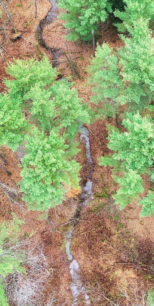
On another piece of VLT-conserved land in Charlotte, beavers have been transforming the valley around a small stream into a diverse wetland complex for years. After exploring the maze of dams, channels, and canals here one January day, I returned to the office to compare aerial maps, including high-resolution drone imagery, which allowed me to see how the dams relate to each other. At least 10 dams of varying sizes occupy the roughly 1,800-foot-long stream reach. These have shifted over the years in relation to each other: as one dam impounded water, flow patterns changed, and beavers responded by building additional structures upstream, downstream, or in newly emergent flows around the margins. They also extended structures farther across the valley. Human-designed BDA projects aim to create functional complexes of dams that will complement each other in slowing and spreading water. The projects I’ve worked on have each included at least 10 structures.
Bringing Back the Bones
“Wood is the bones of a stream,” emphasizes Patrick Hurley, watershed project manager for the Memphremagog Watershed Association, and owner of the restoration firm Windenwater, who has worked on thousands of BDAs in his career. “It holds the river together.”
Those “bones” don’t always form a neat skeleton, but beaver dams and BDAs, intricate in their construction and spaced out along a stream reach, could be thought of as vertebrae that provide critical structure to support the nerve center of the watershed. Hurley’s design map for a BDA project in Barton, Vermont, shows 12 BDAs spaced along two curving, manmade ditches in the Barton River floodplain. Now built, this project is helping bring the floodplain back to life.
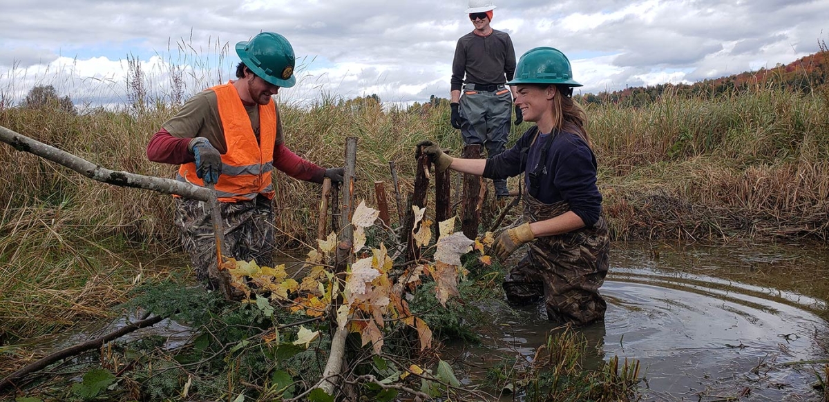
In October 2022, Hurley convened 15 youth crew members and staff from the NorthWoods Stewardship Center to spend two days building the project. The land, part of the state-owned Willoughby Falls Wildlife Management Area, had been ditched historically to allow for agricultural use, and the ditches were continuing to function as drains for this wetland, even though the farming had long ceased. In addition, berms running along the ditches, made of soil that had been dredged when the ditches were dug, also prevented floodwaters from spreading naturally. Hurley hoped that by building BDAs and other woody structures, and removing part of the berm, the project would essentially plug these ditches to stop the wetlands draining, keep floodwaters on the floodplain longer, promote native plant growth, and improve habitat for nearby beavers.
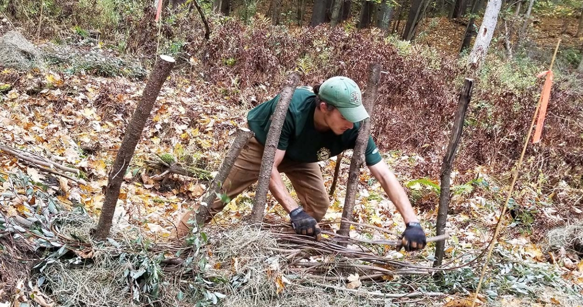
For each BDA, the crew felled and limbed small trees, dragged them up to 1,500 feet from the forest edge to the ditch, cut them into 4-foot posts, sharpened the ends, and pounded them into a line across the water-filled channel. Once a row of posts spanned the stream, crew members wove flexible willow whips, cut from a nearby wetland, between the posts to create a dense basket weave. A second row of willow-woven posts soon paralleled the first, about 18 inches upstream, and the builders filled the space between these with softwood tops, clumps of sedges and root mats cut from the nearby berm that they were dismantling, and handfuls of the berm’s soil. Almost immediately, the structure began to impound water, and the crew moved downstream to repeat the process.
In the months since BDA construction wrapped up, Hurley and the NorthWoods crew have seen the pooling continue; new growth of willow, cattails, and sedges from the structures; sediment build up behind the BDAs; and clearer water downstream, suggesting that the project has been a success. Because this and other BDA projects in our region are still very new, we lack long-term data on their impacts. However, research from England and from the western United States, where BDAs are a more established restoration practice, shows dramatic results, with formerly droughty valleys restored to vibrant riparian complexes.
While beavers lived near the Barton River site prior to this project, they had only attempted one dam at the outlet of the ditch and had not been seen venturing upstream. Perhaps the exposed sites lacked wood and natural cover, perhaps the water flow was off, perhaps the population was still recovering. The beavers did come to check out the new project, though: on day two, the crews found fresh beaver chew marks on the posts they had installed the day before. To Hurley, this was excellent news – perhaps beavers will take on the maintenance and improvement of these human-built structures, saving him the work and probably resulting in a better outcome.
Project Planning
When my colleagues and I want to implement a BDA project, we consider site selection, project goals, overall design, materials, logistics, and permitting requirements.
Starting a beaver-based restoration project centers on identifying an appropriate stream in which to work. BDAs will slow and impound water and expand wetlands. We look for places where the broader, wetter area we hope will develop will not interfere with other uses such as agriculture, roads, buildings, or planned forest management. We look at the contours and qualities of the land, both in the field and using map data. Beavers prefer flat-bottomed valleys, and because I work mostly on lands with active agriculture, I’ve found that flat-bottomed headwater stream valleys with forested slopes offer ideal worksites. Even if the entire valley bottom were to fill with a few feet of water, or a straightened stream were to regain its historic sinuosity and meander across the valley, it would not impact the crop fields above.
Project-scale design involves deciding where to put the BDAs and how many to build along the waterway based on specific project goals. (The three projects profiled in this piece all have slightly different goals.) Once we arrive at a rough design, we determine what kinds of materials we need, how much of these materials we need, and how we’ll get them. We plan where to source posts, weavers, and sod. Obtaining and moving wood can be labor-intensive, so we try to source material as beavers would: seeking out trees within easy dragging distance. Small wood – around 4 inches in diameter – makes ideal posts, and flexible fine stems are great for weaving between them. It’s highly satisfying when we can use posts of invasive European buckthorn. While living buckthorn can degrade forests and wildlife habitat, the wood itself can be useful when incorporated into restoration projects. (Note: many invasive species, including buckthorn, can sprout from live stakes, so it’s important never to use freshly cut material.) For the weaving stems, we use flexible upper branches of freshly cut native trees, or better yet, fresh willow and alder stems that may root and sprout with sufficient soil and water contact.
Sod can be a critical component in BDA projects. We’ve used sod cut from nearby upland areas, or (as in the Barton project described above) it can be strategically moved from places where we want to cut down a steep bank to establish a flood bench or to create a tiny wetland depression. Sod with finer silt or clay components in the soil will pack better than that with a high percentage of sand.
These projects may be intuitive on many levels, but they are also likely to be subject to local, state, and federal regulations and thus require lead time to secure necessary permits. Permit needs differ based on the size and watershed position of the stream, the amount and size of structures being built, the time of year construction occurs, state or region, and potentially other factors. Most of the projects I’ve worked on with Vermont Land Trust, even on small streams, required a permit from the U.S. Army Corps of Engineers because they involve placing fill in a stream or wetland. As a start, I recommend reaching out to a local watershed organization or agency for guidance.
Finally, we go into projects knowing that failure is part of the plan. Some BDAs will inevitably blow apart, but the wood that composed them will end up somewhere, provide “bones” to the riparian system, and form the beginning of a new, natural accumulation of material. Wood can decompose, break, move around, conglomerate into logjams, and cause water to change its course, and with enough of it in a system, there will be minimal soil loss from that system.
Tangible Connections
Restoring streams and wetlands can be highly satisfying and can inspire a deeper appreciation for how natural systems function. “Having the project described doesn’t do it justice,” says Meg Carter, NorthWoods conservation science director, who led youth crews on the Barton River project. “There’s a visible effect of the work that you’ve done. And that touches people in a way that some other jobs might not…. Seeing it, and weaving it, and stomping on it and shaking it around” connected the crews tangibly to the watershed, helping them understand, through drenched waders and freezing fingers, “how much work beavers put into these things and make them 20 times better than we ever could.”
With a BDA project, we may begin as engineers, hydrologists, or ecologists, pontificating about a species of sedge or sediment attenuation or modeling 10-year floods. But once we start working, someone will comment about feeling like a kid playing in a stream, or an artisan weaving a basket. After a while, when our muscles are sore and we’ve gotten into the groove of building a beaver dam analog, there may not be much talking at all. Just a few grunts or a brief, “willows over here,” or, “need more sod,” or, “it’s working!”
In this shift from intellectualizing, to observing and playing, to something even more primal, we become more intuitive participants in our landscapes, getting out of our heads while attempting to restore wetlands and waterways to historic conditions.
Discussion *