
Everybody knows that New Hampshire and Vermont are different. But few know just how dissimilar the so-called twin states are – they’re different right down to the core. Cross the river and the soil’s different, the bedrock’s different, and these differences have greatly affected the human landscapes of the two states.
A story making the rounds is that Vermont came from North America while New Hampshire came from Africa. While evocative, this isn’t true. The bedrock of both states was formed side by side under the ocean off North America and then thrust above the waves by a collision between North America, Europe, and Africa. The crucial difference between the two states’ geology, however, is that Vermont is closer to the center of North America while New Hampshire is closer to the edge. This may seem overly obvious, but it has led to three significant consequences.
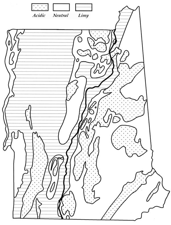
The first is in the composition of the bedrock itself. The entire region was underwater when the rocks of the two states were being formed – the coast was where the Adirondacks are now. Vermont, under shallow coastal water teeming with marine life, was covered by sediments rich in lime. New Hampshire, farther out to sea, was under water too deep for the formation of lime. Nearly 50% of Vermont’s bedrock is naturally rich in limy minerals. In New Hampshire, the percentage is only 5%.
If the continental collision had been a head-on car crash, Vermont would have been the trunk of the car and New Hampshire the hood. So the second consequence of location is that a sizable percentage of New Hampshire’s rocks were smashed so much that they melted together and were recast as new, crystalline rocks: the granites of the Granite State. Just under 50% of New Hampshire is underlain by crystalline rock. In Vermont, by contrast, the figure is only about 20%. Crystalline rocks erode into gravelly soils, and gravelly soils tend to be acidic because water runs right through them and washes out the soluable, acid-resistant minerals.
Third, immediately after the Ice Age, 40% of Vermont was underwater compared with only about 15% of New Hampshire. (Both states are less than 4% underwater today.) This flooding occurred because the ice sheets covering New England were heavy enough to depress the earth’s crust – by nearly 500 feet in northwest Vermont, closer to the center of continental glaciation, by 200 feet at Lebanon/White River, but scarcely at all by the New Hampshire seacoast. The soils from flooded land are rich in fine-grained clays and silts, and these soils hold moisture better, are less acidic, and are more fertile than unflooded soils.
As for those folks who believe that geological differences can be felt immediately upon crossing the Connecticut River, well, they can. The Ammonoosuc fault runs just along the Vermont bank of the Connecticut through the Upper Valley. During the continental collision, a significant chunk of bedrock was thrust up and eroded away along this fault. The result? The differing rocks of Vermont and New Hampshire are now found cheek by jowl, right along the Connecticut River, rather than slowly transitioning over many miles.
So how do these geologic differences affect the human landscape of the two states? These days not much, because fossil fuels influence our local economies far more than local resources. But for most of the two states’ histories, these geologic differences have made a major difference, primarily in the distribution and prominence of agriculture. In 1900, Vermont’s economy was among the most agriculturally based of any of the 50 states while New Hampshire’s was among the least.
Take the mid-1800s, for example, when wool was selling at $70 per pound (in today’s dollars) and agriculture was far and away the most profitable use of land in either state. Northern New England was home to 3 million sheep, nearly two thirds of which were in Vermont. Nineteenth century wool production was entirely dependent on natural soil fertility, not on added fertilizers. In 1860, Vermont’s farmers clipped an average of 6.1 pounds of wool per animal compared with New Hampshire’s 5.0 pounds. Not only were there far more sheep in Vermont but also these sheep were producing 20% more wool than their counterparts in New Hampshire. All because of the soil.
But New Hampshire’s acidic soils were not entirely without economic potential. The sandy soils of the New Hampshire seacoast are ideally suited for growing red oak, white oak, and white pine – three tree species that together are among the world’s best for building wooden ships. While Vermonters were raising Merino sheep, New Hampshire’s coastal residents were world-renowned shipbuilders.
That agriculture has historically mattered far more to Vermont’s economy than to New Hampshire’s, however, is not entirely due to differences in soil quality. It is also due to another natural resource: New Hampshire’s abundance of hydropower. More on that next month.
Discussion *