
Rory Moon can’t wait to climb through the culvert. His father, David Moon, says he can’t just yet. There are measurements to take first. “We have a serious outlet perch, dude,” David Moon says.
“What’s an outlet perch?” Rory, a 13-year-old, had asked the first time the father-son team encountered one earlier that afternoon.
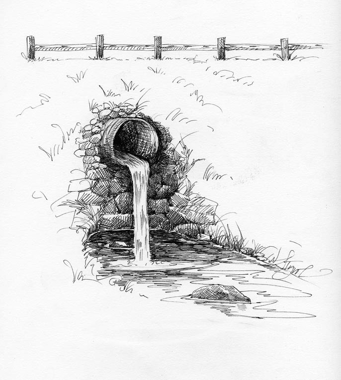
David had explained that an outlet perch is a waterfall that occurs when the outlet, or downstream end, of a road culvert juts out above a streambed. It creates a breach in a natural system that is supposed to be connected – a stream.
David hands Rory a tape measure to gauge the height of the water streaming out of the end of the corrugated metal pipe running under a road in Sullivan, New Hampshire. Twenty-two inches. David writes the measurement on his form. It’s not a good sign. Native brook trout can only jump about 15 inches. This culvert is blocking trout from moving upstream. In hot weather, trout may be stranded far from the deep pools they need to survive.
He writes down other measurements, too for future reference. The culvert is 4 feet in diameter and is flatter than the slope of the rest of the stream.
David Moon is the executive director of the Ashuelot Valley Environmental Observatory, or AVEO, which is working with The Nature Conservancy of New Hampshire to assess how bridges and culverts cross streams and rivers in the Ashuelot River watershed, located in southwest corner of the state.
The information gathered by the project will help anyone interested in improving habitat for trout and will also help the scientists who are working to restore Atlantic salmon to the Connecticut River watershed.
Road and stream crossings such as those Moon is studying affect a wide variety of wildlife that live and travel within a stream corridor. Turtles and crayfish can’t jump, so perched culverts lock them into small sections of a stream. There are three state-threatened turtles in the Ashuelot watershed, Moon notes.
If a stream bank disappears because the stream is squeezed into a culvert, or if the water flows too swiftly through a culvert, animals such as mink, otter, and beaver will cross the road instead and risk being hit by a car.
“We’re not doing restoration work, just assessing the situation,” says Doug Bechtel, director of conservation science for The Nature Conservancy in New Hampshire.
Dozens of volunteers are working on assessing the 1,085 stream crossings identified in the watershed, but after helping to train those volunteers, David Moon has signed up to survey a few of the crossings himself, with the help of his son.
The Ashuelot River culvert operation is one of several pilot projects conducted on Connecticut River tributaries over the last few years. Road crossings on the White River in Vermont, the Greenfield River in Massachusetts, and the Eight Mile River in Connecticut have also been examined.
This summer, in addition to the Ashuelot, an assessment of road crossings in the West River watershed is being conducted by The Nature Conservancy of Vermont. Four interns gathered data on some 500 stream crossings, reports Rose Paul, director of science and stewardship for the chapter.
After Rory and David Moon tick off several more measurements and observations (the culvert is rusty, the water level is the typical low-flow of late summer), Rory gets the okay to head into the culvert. David holds one end of a tape measure at the lip of the culvert.
Rory encounters cracked tar lining the floor of the culvert. He walks deeper and deeper. Soon he needs his father’s help. He’s come to the end of the 25-foot-long measuring tape.
David meets Rory in the middle of the culvert as cars drive on the road above them. He holds the end of the tape measure as Rory unspools it toward the upstream end of the culvert.
There is a drop between the natural streambed and the culvert at the upstream side of this culvert as well as at the outlet. At 17.5 inches, it’s yet another barrier to trout and turtles, although not to father and son.
“It’s nasty,” says David when he emerges from the tunnel. “We are not doing that any more. We’re only going into short culverts with lots of light and air.” (The culverts can also be measured from end to end across the road surface.)
The data from this project will be used to pinpoint the road/stream crossings that are the biggest barriers to wildlife. The long-term plan is for the worst of these to be modified. Someone will also be taking an overall look at all five pilot projects from the four Connecticut River states to see what their data can tell us about stream and river connectivity across the Connecticut River watershed.