Satellite technology and geographic information systems (GIS) now allow us to accurately show how much of a landscape is paved or covered with impervious surfaces. “Paved” is just what it implies and includes parking lots, roads, driveways, and sidewalks. The term “impervious” adds bridges, buildings, and so forth – anything that doesn’t allow rainfall or snowmelt to directly enter the ground.
Why is it important to know this for a region? Many studies have shown that, first, the amount of impervious surface in a region has a direct correlation with water quality. The rule of thumb has been that after a region is more than 10 percent paved or impervious, water quality starts to decline rapidly due largely to road runoff: a messy mixture of oil, grease, heavy metals, and nitrogen. The second reason is that with more imperviousness, there is more flooding, as rainfall is diverted from areas that could have absorbed rain and instead rushes directly and rapidly into rivers and streams, guided there by carefully engineered networks of storm drains and pipes.
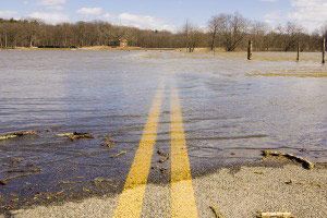
How much of our land is impervious? Nationally, the current estimate is that for the U.S., an area the size of Ohio (41,000 square miles) is now paved. It is no surprise then that around the country, more and more flooding occurs each year due to the increasing impermeability of the landscape. Hundred-year floods, those that have a one percent chance of happening in any given year, are occurring with greater frequency. The flooding we see on the evening news is perhaps as likely to be due to increased imperviousness as from climate change or from weather extremes. U.S. Geological Survey scientists have noted that peak flooding increases downstream of development due to increased flows over greater areas of impervious surfaces.
The mid-May 2006 flooding in southeastern New Hampshire and in Massachusetts and Maine that equaled or exceeded local, 100-year flood levels was due to a powerful storm coupled with more and more impervious surfaces. The area of New Hampshire with the heaviest flooding is also where population growth has been fastest and where construction and paving have been the heaviest. A pre-flood study by University of New Hampshire researchers that focused on southeastern New Hampshire showed that the imperviousness of the region had increased by 46 percent from 1990 to 2000, growing from 4.3 percent to 6.3 percent paved, on average. Also, the acres of imperviousness increased from 0.15 acres to 0.20 acres per person. Paving is not the root cause of flooding, of course, but worsens it effects - speeding runoff and preventing water infiltration into the ground.
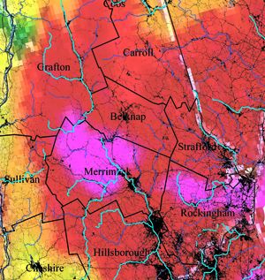
When the 10 counties of New Hampshire are compared with a new national map of paved areas, the four counties with the highest average imperviousness, Merrimack, Stafford, Hillsboro, and Rockingham (ranging from 2 to 6 percent) are also those where the most severe flooding occurred, according to the U.S. Geological Survey.
Locations we like to build in, including gently sloped valleys and floodplains, are perhaps the most important areas to keep as natural as possible because of their role as buffers. Of course, southern New England, with a large population and more urbanization, is even more heavily paved than New Hampshire. But as the Boston metro area continues to move north and as southern New Hampshire and southern Maine urbanize, we will see more paved areas, more impermeability, and more problems there with unusual flooding and declining water quality unless we change our building practices.
Positive changes would be: reducing the number of parking places required for new office buildings, using alternative surfacing methods such as crushed stone or open pavers where appropriate, diverting storm waters into dry wells, catch basins, or man-made sinks before they have chance to reach streams and rivers, and surrounding paved parking areas with grassy swales that slow exiting waters. All these allow for some infiltration of rainwater into the ground.
The abilities of forests and other natural lands to retain and clean rainfall and runoff are called “ecosystems services” by ecologists. Other ecosystems services include: cleaning the air, building soil, taking carbon dioxide out of the atmosphere, providing habitat, protecting diversity, and stabilizing the climate. Ecosystem services are provided free by nature and, because of that, most people take them for granted. Paving eliminates ecosystem services, requires more and more infrastructure to handle storm runoff, and degrades water quality. If we can retain forests, woodlands, and other natural lands, we’ll have cleaner air and water, less flood damage, and reduced costs of maintaining our infrastructure.