
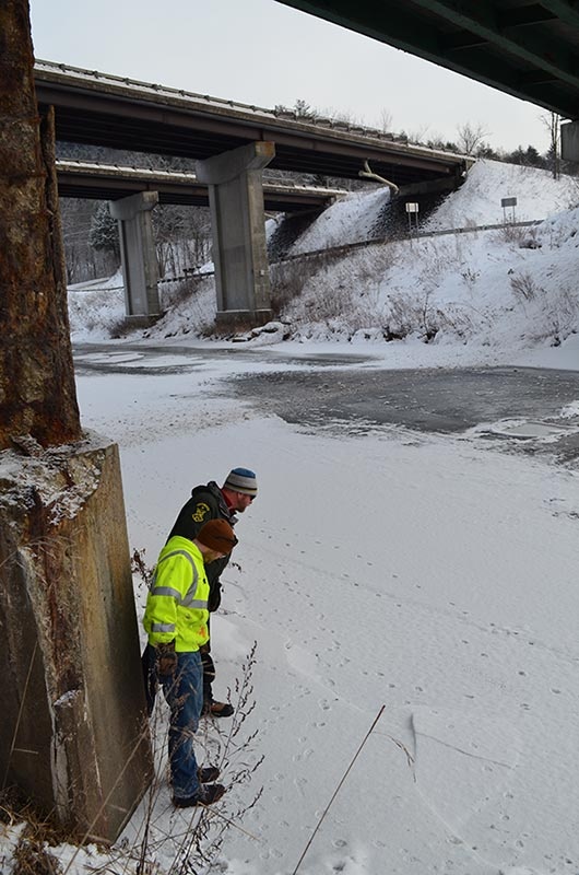
Jens Hilke, a conservation planning biologist with the Vermont Fish and Wildlife Department, stood beside his colleague, James Brady, a biologist with the Vermont Agency of Transportation (VTrans), who wore a neon-yellow jacket. The men were scanning a valley from the crest of a steep slope. This was no secluded mountaintop. To their left, cars and trucks rumbled over two tall bridges for Interstate 89’s north and southbound lanes. To their right, traffic whizzed by on Route 2 over another bridge.
Not a place you’d normally expect to find two biologists.
Hilke and Brady were checking up on a wildlife project in Waterbury they’d been working on together. These major roads, above the Little River and its confluence with the larger Winooski, are known barriers to wildlife movement between the Mount Mansfield and Camel’s Hump State Forests, proven in no small part by the regular presence of dead animals on the highway and by game camera photos. So in 2013, as part of a repaving project on Route 2, VTrans worked with Fish and Wildlife to make changes to the underpasses to allow wildlife to cross safely beneath the three bridges.

Hilke pointed out a flat area halfway down the slope that was designed specifically for wildlife travel, especially large mammals. To create this passage, and to make it attractive to animals, an excavator added dirt to fill in and smooth the holes between the riprap (chunks of rock) that extends from the bridge abutment to the riverbank. Animals with hooves, such as deer and moose, avoid jaggedly uneven terrain such as riprap. The excavator also added soil and formed a flat area that resembles a woods road or a trail running along the side-hill.
The scientists scrambled down the slope and followed the shelf. Red fox and bobcat tracks confirmed that animals were using this underpass. Game cameras (part of Vermont’s complement of 124 cameras used to monitor wildlife’s interaction with roads) mounted on concrete bridge supports have photographed deer, fisher, and mink. Hilke mentioned that, along with the investment in infrastructure, conservation easements will need to be secured (or zoning changed) to ensure that adjacent private lands between this wildlife crossing and the nearby state forests are not developed.
Close collaboration between transportation and wildlife agencies and other partners is essential for implementing projects like this one, and Vermont has been a leader in this regard. The state’s agencies have worked on wildlife crossings together for almost two decades. Fish and Wildlife now reviews projects before VTrans draws up the plans, and its input is incorporated into the design. Education on road ecology for VTrans staff, such as training sessions on wildlife ecology and track identification run by the nonprofit Keeping Track, have been instrumental in generating support, said Hilke.

ANIMALS NEED TO MOVE
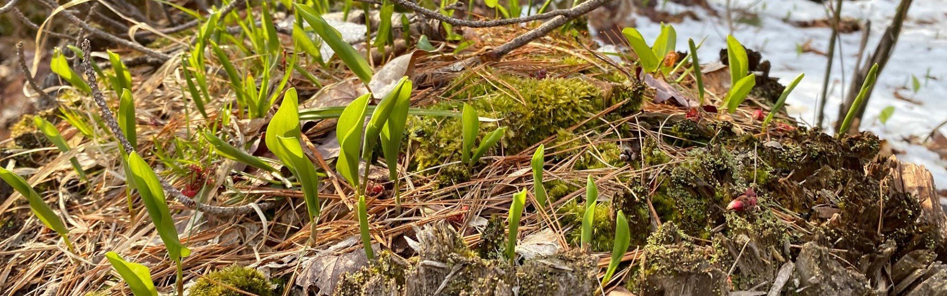
Projects like Vermont’s bridge underpasses are being carried out around the Northeast as states work to help wild animals move across a developed landscape. Animals need to cross roads and other manmade infrastructure such as railroad tracks every day or in certain seasons to find food, escape predators, search for mates, give birth, or lay eggs. Yearling moose, lynx, and other juveniles need to disperse to new areas. Some snakes seek special underground hibernacula before winter. Larger animals and predators tend to move longer distances than smaller animals, but all need to move. And wildlife movement across a region is important for maintaining gene flow between populations and preventing inbreeding.
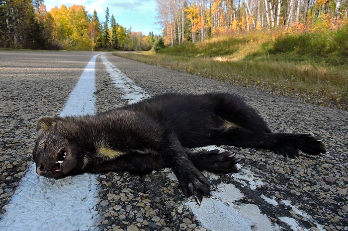
Highways and other development are proven barriers to wildlife. A study of bobcats in New Hampshire, for example, found a genetic difference between bobcats on the east and west sides of Interstate 93, indicating the spotted felines are not crossing the highway frequently to breed. This effect has also been documented in other species. Animals can be deterred from crossing roads by traffic volume, noise, pollutants, and lack of passage opportunities. Carcasses along roadsides attest to the fate of many that are not. This is no small matter: vehicle collisions are the leading cause of wildlife mortality in the US, with a study by the Federal Highway Administration estimating that between one and two million large animals are killed on America’s roads each year. Wildlife collisions, of course, also pose a hazard to drivers.

SAVING MASSACHUSETTS TURTLES
Massachusetts’ first projects to improve road crossings for wildlife were in 2000, and were designed specifically for rare turtles, according to Tim Dexter, fish and wildlife program coordinator with the Massachusetts Department of Transportation, and Dave Paulson, an endangered species biologist with the state’s Division of Fisheries and Wildlife. After numerous reports of turtle mortality across the state, the two agencies partnered with various concerned organizations and local citizens to collect data on road-killed turtles. The study identified hotspots; at the worst one, more than 100 turtles were killed in a single year. The turtles there were attempting to cross between extensive wetlands on both sides of the road or to dig nests in the gravel of road banks; their armored shells were no match for cars.
Because of turtles’ low reproductive rates, losing even a few adults can dramatically affect a population, especially for the rare Blanding’s, wood, and box turtles. In response, the agencies installed wide tunnels with natural bottoms beneath the road that were accompanied by fencing to guide the turtles toward the passages, and roadside signage alerting motorists to beware. The result was reduced mortality at these locations by as much as 90 percent.
In addition to the standard wildlife crossing signs common around the region, another kind of tool used in Massachusetts is temporary flashing signs erected during prime crossing seasons, such as when moose are in rut in the fall.
Massachusetts has now been working on wildlife road crossings for almost two decades and has completed more than 100 projects, mainly retrofits of existing structures. As in other states in our region, funding constraints don’t usually allow for the construction of new structures solely for wildlife except in the case of major projects – like new interchanges or highway widening – where federal funding is available, explained Dexter. Much good work, though, can be done on a smaller scale. For instance, at stream crossings in Massachusetts (and other northeastern states) large culverts with natural bottoms have replaced undersized culverts, encouraging passage for aquatic and terrestrial animals and handling floodwaters better, thereby achieving multiple goals.
Initiatives of this type in the Northeast are part of a national and international movement to improve connectivity across a human-dominated landscape. America’s western states have been at this work longer and have, in some cases, built huge overpasses above highways specifically to accommodate wildlife. Overpasses are extremely expensive and are not common in our region, as we don’t have high densities of large mammals or herds migrating seasonally. Also, most of the land here is privately owned, which makes acquiring land or easements for crossings more challenging. Out West, overpasses often connect large blocks of public land.
SAFE PASSAGE FOR NEW YORK CRITTERS
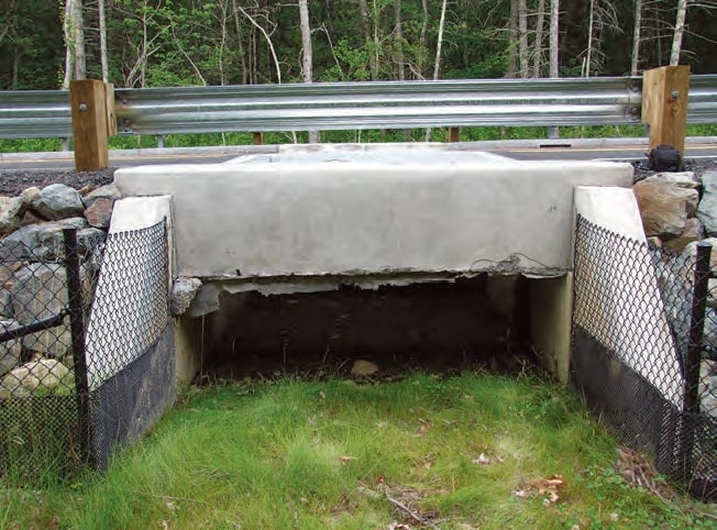
Wild animals tend to follow stream (or riparian) corridors through the landscape, but some animals do not like to get wet. For this reason, some states have installed “critter shelves” in culverts or upgraded to underground crossing structures large enough to maintain streambanks inside. Alissa Rafferty, wildlife monitoring project manager, and Dirk Bryant, director of conservation programs for The Nature Conservancy’s Adirondack Chapter, worked with the New York Department of Transportation to install a 138-foot-long critter shelf for small to medium-sized mammals such as raccoon and fisher in a culvert under Route 12 near Boonville. The wildlife shelf is a platform constructed of steel mesh that is positioned above the water and bolted to the inside of the culvert.
This was New York’s first critter shelf project and the first time such a design was used in the Northeast, said Rafferty. The technology was developed by a Montana biology professor and a steel manufacturer, and has been used widely in that state. Through winter tracking studies and remote camera monitoring, The Nature Conservancy (TNC) identified Route 12 as the biggest barrier to wildlife in the Black River Valley – and this culvert as a prime crossing opportunity. Many culverts are used by wildlife, but animals weren’t using this one to cross the road because it is filled with water year-round, explained Rafferty. The ideal solution would have been to replace the culvert with a larger one with a natural bottom and streambanks inside, but that would be very expensive. The critter shelf, which cost $28,000 and was paid for by TNC, was a relatively low-cost fix and is serving as a pilot project. DOT handled the installation and plantings around the site to encourage wildlife to use the shelf. There is good forest cover on both sides of this crossing, and one side is protected by a conservation easement held by a local land trust. TNC is reaching out to nearby landowners about putting up game cameras on their properties to help monitor crossings and has found that viewing photos of wildlife on their land has generated enthusiasm for these projects among local people. It may eventually result in more conservation easements.


HELPING MAINE’S MOOSE, MINK, AND LYNX CROSS THE ROAD
Richard Bostwick, a biologist with the Maine Department of Transportation, has worked on wildlife crossings for nearly 15 years. His interest started in 2003 after Maine DOT staff and transportation officials from nearby states attended the International Conference on Energy and Transportation in Lake Placid, where there was a workshop about wildlife crossings. In 2004, he and the others helped organize the first Northeastern Transportation and Wildlife Conference in Vermont. It is now held every other year.
Over the years, Maine has completed a variety of projects aimed at helping wildlife cross manmade barriers. These have included creating shelves with a natural substrate under bridges for endangered turtles in York County and encouraging the endangered New England cottontail to cross beneath bridges in southern Maine by providing brush piles and plantings for cover. Up north, a six-foot-wide dry culvert was installed for lynx passage near Portage; an oversized bridge was built in Gorham to allow moose, deer, and other animals to pass beneath; and dedicated wildlife underpasses were constructed below new highways in Brewer, Holden, and Presque Isle. Especially when it comes to providing access for large animals, it is usually much easier to add these features when building new roads than to retrofit existing roads, observed Bostwick. Maine also tracks large animal crashes and is partnering with the citizen science Audubon Road Watch program to get better data on wildlife crossing sites.
STAYING CONNECTED
Animals may need to move farther to adapt to climate change. “This region is incredibly important for northward-moving species,” commented Jessica Levine of TNC Canada, an affiliate of The Nature Conservancy. Levine coordinates Staying Connected, a partnership of 46 northeastern and Canadian transportation and natural resource agencies, conservation nonprofits, and universities working on connectivity. “We are fortunate to live in a relatively intact region of healthy forests, but fragmentation is a threat, and we need to keep pathways permeable for wildlife,” she stated of the group’s mission.
The Staying Connected initiative is working to connect large blocks of core forest habitat in critical linkage areas in the Northeast and Canada: New York’s Tug Hill Plateau to the Adirondacks; the Adirondacks to the Greens; the Greens to the Taconics; Vermont’s Worcester Range to the Northeast Kingdom and to northern New Hampshire and western Maine; Maine’s North Woods to Quebec’s Gaspe Peninsula; and New Brunswick to Nova Scotia. More than 80 people from different organizations (including those interviewed for this article) are participating in this effort; teams in each linkage area meet regularly to collaborate on projects. Partners also coordinate projects across the region and share success stories and strategies.
In addition to creating wildlife-friendly road crossings, Staying Connected partners are conserving the parcels of land in settled valleys that serve as stepping-stones between core habitats, as well as riparian corridors through farmland. Together, partners have protected more than half a million acres in the linkage areas through acquisition or easements. They also work with towns on planning and zoning. “Landscape context is very important for which road crossing structures are moving wildlife,” said Hilke. “The structure is just the pinch point between forest blocks.”
Land-use planning and conservation at crossings and connecting the crossings to nearby forests are critical to their long-term success. Hilke described an early Vermont wildlife structure as an illustration of why a holistic approach is required: A dry culvert was installed under the Circ Highway in Essex to help deer cross between their summer and winter range, but subsequent subdivision and development compromised the habitat and, at least as far as animals are concerned, the structure is now “a bridge to nowhere.”
In a boost to this work region-wide, the significance of landscape connectivity and the need to work across borders was acknowledged by the New England governors and eastern Canadian premiers when they adopted a resolution at their 2016 conference recognizing the Northern Appalachian-Acadian forest “as the most intact, contiguous temperate broadleaf forest in the world” and “the importance of ecological connectivity for the adaptability and resilience of our region’s ecosystems, biodiversity, and human communities in the face of climate change.”
Back in Vermont, Hilke and Brady traveled west to check out a tall concrete tunnel built to accommodate a brook that leads under Route 2, the Interstate, and railroad tracks. When the water is lower, there is a shelf on one side. This culvert looks like an ideal passage for wildlife, but the state’s remote cameras have not shown much use. The cameras have photographed people driving ATVs and even Jeeps through the tunnel, though – likely one reason wildlife are not using it.
They looked at an alternative crossing a couple of miles away. Here, a brook in a deep ravine flows through a five-foot metal culvert beneath Route 2 and the Interstate. Deer tracks paralleled the road and led downhill into the gorge. Many other tracks were there, too: coyote, snowshoe hare, mink. Monitoring cameras strapped to trees have shown abundant wildlife activity. However, the culvert’s size and metal bottom are not conducive to large mammal passage. When the Interstate was originally constructed in the 1960s, undersized culverts were installed, explained Brady. He and Hilke hope that VTrans can replace this culvert with a larger, wildlife-friendly structure with a natural bottom. But digging through 40 feet of fill to get to the culvert will make this an expensive project, so it will probably not be replaced until its useful life is over.
Despite funding limitations and other challenges, these efforts across the Northeast are adding up and are beginning to reconnect our broken landscape, ensuring that salamanders can slither to vernal pools to breed and lay eggs, that a mother bear and her cubs can visit an oak stand to feed on acorns, and that a bobcat can travel to find a mate.