
A magnificent 92-mile-long ribbon of interconnected lakes, ponds, rivers, and streams flowing through the heart of Maine’s vast northern forest, the Allagash Wilderness Waterway (AWW) features unbroken shoreline on the headwater lakes and free-flowing river along the lower waterway. The AWW’s rich culture includes use by Indigenous people for millennia and a colorful logging history. In 1966, the Maine Legislature established the AWW to preserve, protect, and enhance this unique area’s wilderness character. Four years later, the AWW garnered designation as a wild river in the National Wild and Scenic Rivers System (NWSR). This year marks 50 years of federal protection under the NWSR Act.
The AWW provides visitors with a true wilderness experience, with limited vehicle access and restrictions on motorized watercraft. Some 100 primitive campsites dot the shorelines, and anglers from all over New England come to the waterway in the spring and fall to fish for native brook trout, whitefish, and togue (lake trout), and to ice fish in the winter.

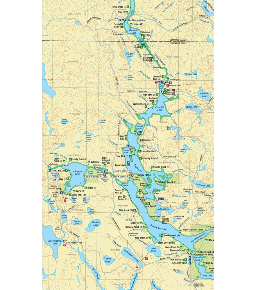
The northward natural flow of Allagash waters from Telos Lake to the St. John River presented a challenge to Bangor landowners and investors who wanted to float logs from land around Chamberlain and Telos lakes southward to mills along the Penobscot River. So, they reversed the flow by building two dams in 1841. CHURCHILL DAM raised the water level and Telos Dam controlled the water release and logs down Webster Stream and eventually to Bangor. Chamberlain Dam was later modified to include a lock system so that logs cut near Eagle Lake could be floated to the Bangor lumber market.

THE TRAMWAY HISTORIC DISTRICT, which is listed on the National Register of Historic Places, includes two 100-ton locomotives that sit a couple hundred feet from the shore of Eagle Lake, seemingly dropped into the wilderness. The tramway located near the trains is a 3,000-foot mechanical system once used to move logs between Eagle and Chamberlain lakes. The materials to build the tramway were brought to Greenville by train during the summer of 1902. They were transported the length of Moosehead Lake by steamboat, then hauled along the shore of the Upper West Branch of the Penobscot, across the northern end of Chesuncook Lake, across Mud Pond Carry and finally up Chamberlain Lake to the tramway by horses pulling sleds.

The Allagash Wilderness Waterway Foundation recently published Allagash Explorer, a pocket guide that explains and highlights the cultural history and natural resources of the Allagash Wilderness Waterway from its earliest times to the present. See AWWF.ORG for more information and a list of locations where Allagash Explorer can be purchased.

Visitor Use Survey
During the late spring, summer, and fall of 2019, the AWW partnered with the University of Maine’s School of Forest Resources to conduct a survey of visitors to the waterway. The visitors were asked questions on their method of travel, length of stay, and camping conditions encountered. The study provides baseline data and the ability to monitor stewardship efforts in protecting visitor experiences on the AWW, to recognize successful management efforts, and to identify areas that may need attention to improve the quality of the experience. The full report will be available on the AWW conditions and alerts page at maine.gov/allagash in January 2021.
Here are a few highlights from the survey:
49% of visitors were from Maine followed by Massachusetts (12%), Connecticut (7%), New York (4%), and Vermont (4%).
94% reported to have seen bald eagles. The other most common wildlife seen were moose (84%), loons (84%), blue herons (44%), osprey (37%), and deer (33%).
82% of visitors used a canoe without a motor, followed by a canoe with a motor (11%), a kayak (11%), and a boat with a motor (4%). (Watercraft type/use is carefully regulated by AWW rule.)
86% of visitors reported their experience as very good and 13% of visitors reported their experience as good, highlighting clean sites, solitude and remoteness, scenic and natural beauty, peace and quiet, and good weather.
90% of visitors rated natural environment experiences or conditions as “very important,” followed by exploration and remoteness (82%), no litter or waste (77%), personal and social experiences (66%), and solitude (64%). Hunting, fishing, and gathering were viewed as very important by 21% of visitors.