I’ve never traveled to Bermuda. It’s not that I have anything against it. It’s just that I feel as if I’ve been there enough already.
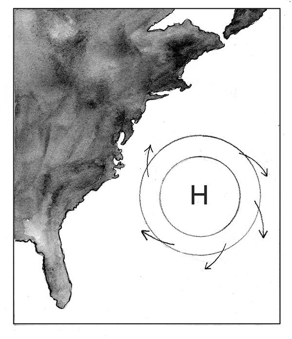
The most prominent summer weather feature in New Hampshire and Vermont is called the Bermuda High, “high” being short for high-pressure system. When the forecast calls for the three H’s - hazy, hot, and humid - you can be pretty sure that the Bermuda High is in the neighborhood.
Though we don’t often consider it in such terms, the atmosphere - or more technically, the troposphere, the lowest layer of the atmosphere where weather takes place - has topographical relief. There are high peaks and low valleys. The highs may be tens of thousands of feet higher in altitude than the lows, and their bases can cover hundreds of thousands of square miles of land and ocean.
The high that often afflicts us in the summer is named after Bermuda because the approximate summit of this massive ridge of air is usually centered more or less in the vicinity of that island. The Bermuda High is one in a series of high-pressure ridges that form in the summer months in the latitudes just north of the Tropic of Cancer. These ridges can become stationary for weeks at a time, completely dominating the weather underneath them and leading to those sultry summer days when it seems that not a breath of air is moving and when the whole idea of weather as a changeable phenomenon seems implausible.
How do these ridges form? The sun, acting like a giant one-bottom plow, cuts an atmospheric furrow around the globe directly beneath itself and flips the displaced air off to the side. These piles of hot, humid air grow taller and taller with time, creating enormous high-pressure systems. When the sun’s zenith is north of the equator, the pile above Bermuda grows steadily larger until, at the height of summer, it spills over to our latitude.
The sun isn’t literally plowing up air and flipping it off to the side, of course; it’s simply heating the air up. Heated air expands, rises, and immediately starts heading towards cooler climes, in this case, toward the North Pole. The deep trough directly under the sun, where the air is rising quickly and exiting the area, is full of low pressure systems, where the storms of summer - monsoons and hurricanes - are created. The tall piles of humid air to the north of the tropics, meanwhile, bear down on us, the collected weight of all that extra air increasing the barometric pressure on the ground. Hence the term “high pressure system.”
“One of the brightest gems in the New England weather is the dazzling uncertainty of it,” wrote Twain on a day when the Bermuda High was nowhere to be seen. Our typically variable weather is a result of the jet stream regularly oscillating overhead, pulling moisture and storms along with it. When the Bermuda High is in place, however, the jet stream is blocked and diverted far to the north, keeping the storms and cooler air bottled up over Canada. Summer in New England reaches its peak intensity.
How long the Bermuda High sets up each summer has a great impact on whether we have a hot, dry summer or a cool, rainy one. Daytime and nighttime temperatures under the High tend to be 20 degrees or so warmer than those north of the High, meaning daily highs and lows of mid-90s/upper-60s instead of upper-70s/low 50s. Usually the High will set up for a week or so each summer, sometimes in several shorter stints, sometimes for one long visit. The past two summers have seen relatively few days with the High fully in place. On the other hand, the summer of 1988, one of the hottest ever in New England, featured the presence of the Bermuda High for weeks on end.
The presence or absence of the Bermuda High helps explain why forecasting long-term temperature trends can be so maddening in a place like New England. If the Earth’s atmosphere warms by 5 degrees F or so over the next century, as scientists predict may happen, that may seem like not a big deal - a summer day might top out at 78 degrees instead of 73 degrees, right?
Not necessarily. A 5 degree average warming could provide enough extra heat that the Bermuda High would affect us for six weeks each summer instead of only two, meaning that our summer temperatures could be 20 degrees higher for weeks on end. Instead of sharing the warm days, cool nights of adjacent Canada, we’ll be under the sultry days and fetid nights of a place, apparently, like Bermuda.
Maybe I should visit Bermuda after all. I hear they have a sea breeze.