
Charlie Cogbill has spent a large part of his career studying a forest that no longer exists: the pre-settlement forest in New England and New York. A plant ecologist, Cogbill began this work while he was completing a master’s degree in the 1970s at Hubbard Brook Experimental Forest in Woodstock, New Hampshire, studying forest dynamics. As he tried to better understand the ways in which human activity has changed our forests, he began his search for baseline information on the forest that was here before European settlers began to clear the land for agriculture.
His primary research tools are archives, located in town halls and other repositories, of land surveys made during the seventeenth and eighteenth centuries. Many of these archives contain “lotting” surveys – the survey by which the proprietors of a new town divided the town into lots, which were then sold or granted to the earliest settlers. At each lot corner, the surveyors tended to place a monument, often a post or stake or a pile of stones. They also routinely made mention of a nearby “witness tree.”
Cogbill’s methodology is to read those surveys and compile data on every tree that is mentioned. He then calculates the relative abundance of the many tree species in each town, fighting through naming nuances and regionalisms. Through further statistical analysis and a reliance on his background in field ecology, he has been able to paint a detailed and localized picture of what the forests of New England and New York looked like back when those forests were being settled by Europeans.
Cogbill’s research parallels similar efforts underway in the Midwest and, closer to home, at the Harvard Forest in Petersham, Massachusetts. He’s been working on this since the 1970s, and in that time, he and others have tallied more than 500,000 trees. To find out more about his work, we interviewed Cogbill in December at his home office in Plainfield, Vermont. —Virginia Barlow and Stephen Long
Northern Woodlands: Was the first lotting survey you studied – at Hubbard Brook – typical of what you would later find elsewhere?
Charlie Cogbill: It mentioned 256 trees, which is typical of a good grid town, a town that’s laid out all at one time in a perfect grid. Almost every town is lotted, but only half to two-thirds of the towns have the survey preserved in a manner such that we can get tree information out of it. Some towns in Connecticut have irregular, very small lots that might have 10 or 15 corners. There you might have a record of well over 2,000 trees in a town.
NW: The trees were usually not the corner monuments themselves right?
CC: In surveyors’ terminology, they weren’t all monuments. Except in the early days in southern New England [when lots were settled before they were surveyed], lots were laid out on plats ahead of time, in somebody’s tavern or living room. Then the surveyor went out and surveyed with compass and chain. When he came to a corner, he very typically put either a post or a heap of stones or a stake there, and then used a nearby tree to reference that. We think of it as being the nearest tree, although we can never prove they were locked in to using the nearest tree.
NW: Wouldn’t there be a bias toward big trees?
CC: There certainly is a size range that the surveyors would be interested in. The really small ones, shrub species or smaller examples of trees, would not be used. Big trees? There’s a lot of speculation over this – if it’s too big, it’s not going to last very long, but then it might be easier to see, so you might want to go to it anyway. I’ve heard say, “they wouldn’t want to mark a big white pine because they might blemish it.” To me it’s all talk, and there’s virtually nothing to indicate there was a consistent range-wide bias that’s really affecting it. The trees had to be big enough to serve as monuments for the near future, at the time they blazed them.
NW: Have you ever found any of the actual trees?
CC: It’s certainly possible one’s out there. We know where the corners are. We know what tree was marked there. Many people have gone back to those corners and checked to see whether that species is still there, and that’s really straightforward. But I have never run across an actual 1800 tree. Even though corner trees are special and tend to be preserved because they’re on boundaries, and they could live that long, I’ve never been able to find a New England tree from the surveys.

Charlie Cogbill
NW: Let’s talk about what species were there. I think your findings on pine, for instance, are very interesting.
CC: Pine is a tree that has a huge reputation for being abundant, but it simply wasn’t a major tree on the uplands in northern New England. It shows up less than one percent regionally. It was very uncommon.
There were areas along the rivers that had very merchantable pine that was harvested early on. Otherwise, in the uplands, they didn’t have very much, or had a scattered tree here or there. The witness tree surveys show that pine is very localized in the major southern valleys. Apparently, a lot of it was pitch pine, so you get down to the southern Connecticut valley in Massachusetts and the Merrimack valley and the Saco valley, the Penobscot, you’re getting lots and lots of pine. It’s not surprising that it would be pitch pine because there are remnant (very remnant) pitch pine plains there. And there was some white pine and occasionally red pine.
NW: What other species have shown a big shift?
CC: There’s been a monumental shift in the amount of beech from pre-settlement days, when there was a huge amount of beech everywhere. Northern New England has seen a major decline, a lowering of the representation of beech and spruce. Beech, especially. It was 40 percent of the original forest throughout almost the entire area. Not every place was 40 percent, but it averaged that. Today, according to FIA (forest inventory and analysis, done by the USDA Forest Service) figures, it’s more like 15 percent.
The major story is that beech has been replaced by maple. Whether one specific area of beech was replaced by maple forest is not easily seen, but the overall shift is clear.
NW: The decline of beech isn’t related to beech bark disease, is it?
CC: Beech bark disease is a major factor in decline of beech, but it only started in the 1950s in Nova Scotia, then reached our area in the 60s and 70s and really got going. So it’s a recent thing. When I’m talking about beech decline here, it’s a 200-year-old trend, and it’s been going on since then. It didn’t just hold at its original level until the 60s and then all of a sudden fall apart. Even more important, the pollen records show that beech has been in decline for close to 2,000-3,000 years. It was even more abundant than this 40 percent 3,000 years ago.
NW: Going back to bias, couldn’t there be a bias toward beech? It’s so apparent visually in the forest.
CC: It’s apparent visually, and it’s got smooth bark. It’s certainly the “initial tree” – it would be easy to scribe, but is that the case or is that not the case? Yes, you can make a good argument [for a bias], but I see no hard data yea or nay on it. At face value, we have to accept what the data say.
NW: You can inscribe a beech and come back in 20 years and see what was written…
CC: There’s a big difference between blazing and scribing and just naming. [Trees] might serve slightly different purposes for those three functions. It might be easier to blaze a tree with a certain type of bark. This comes back to haunt me and other researchers with the beech question.
I always argue that these data are coming from thousands of surveyors over literally a hundred years. If they were biased for beech, which probably a few were, to really skew the data, you are going to have to have hundreds of people biased toward beech forever, and I find that much harder to believe, that they all loved beech.
NW: So much depends on the surveyors. Did they all receive the same training?
CC: There were a few journeymen surveyors, but they weren’t really trained. They were all self-trained. People who did surveys, most of them weren’t surveyors, that wasn’t their only profession. Back in the Colonial days, usually it was a local who was educated and who owned a compass and a chain, someone who did it not just once but fairly regularly.
There was some attempt to pass the word around. There was one book written by Love in England on surveying in seventeenth century, and I’ve read it and read the instructions about how to do it.
NW: It doesn’t tell you to go find the nearest beech?
Since pre-settlement times, spruce has declined significantly,
not just in the spruce zone of the high mountains
but also in the mixed woods on the uplands.
CC: (laughs) No, the British didn’t mark trees, they had hedgerows. They had existing fence rows. Marking trees seems to have been an American tradition for the most part. I’m trying to find how that tradition arose, partly to try to find what the biases were or what the conditions were: nearest tree or size of tree.
Sometimes they would mention the bearing and distance to the witness tree, in later surveys more than earlier. You can go and find all the distances to beech and all the distances to everything else and see if they were going farther to get a beech, and you don’t find it. You find the distances to beech the same as the distances to other species.
NW: Why can’t we look at the remnant examples of old growth forests for a picture of the pre-settlement forest?
CC: It is certainly a wonderful adjunct. How I originally approached the question about what was here originally was always looking at the remnant patches.
We have patches that have survived for a long time, but almost to the one, they survived for very straightforward but significant reasons: they weren’t logged, they weren’t sought for clearance of land, they weren’t agricultural, they couldn’t be gotten to, they weren’t merchantable, they weren’t operable. They are the oddballs, they are the extremes. What I’m really looking for is what are the characteristics of the common, the representative, the general, and the old stands are the flip side of that. That doesn’t mean they aren’t useful. They are great natural systems, they don’t have human confounding factors going on in them, they have natural dynamics.
There are all these stories of these classic stands of cathedral pines. Almost to the one, those big stands, whether they be College Woods in Durham or the Brunswick Pines, or the Cathedral Pines in Connecticut, they are all old fields. They’re Colonial old fields, but old fields. We have wonderful old-growth sugar maple, and almost to the one they turn out to have had at least some sugarbush management.
NW: It’s too bad all the maple and birch species are lumped together.
CC: Almost all the maple in the surveys is what we call sugar maple today. Almost all the birch was in the northern areas, what we call yellow birch today. The patterns are strong enough and consistent enough across the region that I’m very firm in that they represent what’s going on in the original forest. Red maple just wasn’t around. White birch was very rare.
NW: White birch is an early successional species, and so is poplar. Neither of them shows up much in your model. Does that mean there was very little early successional forest at that point?
CC: Two things. Your observation is true. The so-called early successional species – and it includes cherries and ash to a degree – all those species are very rare early on, very rare. And it means that there weren’t large areas of recent disturbance. That’s very true.
Another way to look is not at the species but to look at the actual disturbances mentioned in the forest surveys, what the surveyors mention as burned land, windfall land, or hurricane land, or land they had trouble getting through: thick growth, or young growth. There are all sorts of ancillary descriptions that go along with the surveys, and if you add them up, less than one percent of the land was described in a sense that, ‘this was young, this was early successional.’
NW: What you’re saying is that very little was disturbed.
CC: Very little has disturbance of a severe enough nature to be noticed, or support tree genera that are responding to those events.
NW: You said earlier that there’s also been a decline in spruce. Tell us about that.
CC: The surveyors didn’t distinguish between red and black back then, but spruce has declined significantly, not just in the spruce zone of the high mountains but in the mixed woods on the uplands. Not necessarily in the valleys – there was always less of it there. It was a major representative in the mixed woods in southwest New Hampshire and the Piedmont of Vermont. It’s still there as a species, but it’s not a major player in the forests.
NW: Is its decline linked to acid deposition?
CC: I cut my academic teeth on that question. There are selected places that are more susceptible, where spruce has been pushed a little bit. But I don’t buy the idea that 100 percent of the decline of spruce is from acid deposition. Certainly it’s involved – there has been die-off, a decline. Acid effects on physiology are real, acid’s effects on soil leaching are real, but spruce is holding on. Tom Siccama, one of the people involved with acid deposition research from the very beginning on Camel’s Hump – the poster child of the decline of spruce – says that acid depositional effects, if they were there, are in remission. Right now, spruce is doing all right.
NW: Doesn’t the effects of acid rain have something to do with cold tolerance?
CC: There’s a linkage with cold tolerance, and certainly if we were to get a snap of the right weather and the right combinations, we could get another set of reddening-off and decline. In other words, if we went over a cliff in the ’60s, right now we’ve landed on a ledge.
Coming out of the 1800s, spruce was removed as a player from the mixed forest, which is where it was most prominent. The forest we now see at Hubbard Brook, which was mostly spruce mixed with northern hardwoods, is now northern hardwoods. It’s gone from our minds that that used to be where spruce was. That’s not acid deposition. That happened before acid deposition. That was land use, and it’s the Westveld enigma. He was a Forest Service silviculturist in the 1940s. He said when spruce was logged out of the mixed woods, it didn’t come back.
NW: Hasn’t the composition changed in spruce-fir forests?
CC: Not to oversimplify, but if a forest used to be dominated by fir, and then you removed any remaining spruce, you’d end up with even more fir because logging practices themselves promote the advance regeneration of fir over spruce. It gets into this vicious cycle, and spruce is removed from the picture. But what we’re catching in the pre-settlement data is a time, at the tail end of the Little Ice Age (from 1450 to 1850 A.D.), when spruce was more prominent. And to say that acid deposition is causing the decline is begging the question. The major decline was land use and logging, way before acid deposition came in and gave it an extra blow.
There are still places supporting decent spruce. Most of the spruce decline we see in terms of die-off is on the western edge of the range, in the Adirondacks, then secondarily in the Green Mountains, and not much in the White Mountains, and hardly any in Maine.
NW: Climate change is the other environmental factor that we’re all thinking about. How will that affect forest composition?
CC: One of the great generalities of climate change is thinking of the vegetation in terms of zones. There’s an oak zone, a northern hardwood zone, a boreal spruce-fir zone, and with climate warming, those zones shift. And there have been huge studies done predicting what that shift will be. You hear talk that there will be no more sugaring in Vermont, that it’s all going to go to Canada, and I think these data put a bit of perspective on that.
Even though there are real zones, they show that the shifting of zones with climate is not a simple, linear shift. Each species is behaving in its own way. The zones are changing through time, the composition 5,000 years ago isn’t the composition today, even though it’s still northern hardwoods. What I really think is most significant is the boundary between the oak and the northern hardwoods, or between oak and beech. To simplify it, this boundary has held its ground for the past 250 years, in spite of a large degree of climate warming.
We’ve warmed up in northern New England 2.5ºC coming out of the Little Ice Age – 1816 is when it cracked – through the present. Which is about the same order of magnitude of some of the lower bounds of future human-induced warming. And apparently that boundary between oak and maple hasn’t moved in a large enough way that it really shows up at the scale we’re looking at here. To me, saying that we’re going to lose all the sugar maples because the oaks are going to invade northern new England, that isn’t the story. That isn’t the perspective you get here. You do get changes with climate, but you don’t get the wholesale zonal changes. Or at least the wholesale zonal changes are not as quick. There’s a lag. Trees last for 200 years, and it might take 200 years of warming before the remnant trees are finally clawed loose when they turn over. It isn’t as simple as it’s been made out.
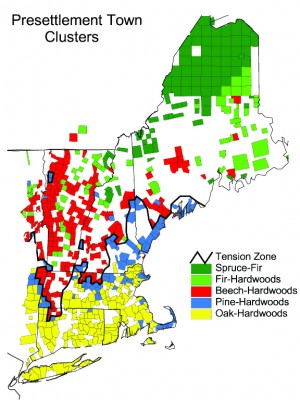
NW: On your map of the pre-settlement forest, you show a clear southern zone and a northern zone and another zone in between.
CC: That’s the tension zone. In a very short range of space, there’s a major shift from southern to northern, with a whole host of things going on. There’s a compositional shift and almost a discontinuity. There’s a whole lot of things – fire, maybe aboriginal influence – going on south of that zone that maintain oak, and those things don’t go on north of the zone.
NW: South of it is oak-hickory?
CC: The southern New England forest I like to think of as just oak or oak-dominated. Hickory is certainly one of the characteristic species, but it isn’t a typical oak-hickory zone. It was oak with some hickory and with some chestnut. The northern zone was characterized by beech with northern hardwoods and with hemlock. But it wasn’t a beech-birch-maple-hemlock forest. It was a beech forest for the most part, and there were pockets and mixtures of sugar maple, a little bit of birch but not much, and hemlock in very select places.
NW: Within the tension zone, do you see a sharp transition?
CC: It’s not really a species transition. It’s a forest type transition. Think of the landscape as made up of a lot of oak forests and a lot of beech forests. The oak forests were on one set of conditions, the beech forests on another. In the tension zone, there is very rapid change of the proportions of those two types. South of the line, the vast proportion of places are oak with very little beech; north of the tension zone, the vast majority are beech with very little oak.
NW: In William Cronon’s Changes in the Land, he discusses the influence of Native Americans on the forest in southern New England. You’re saying there wasn’t the same sort of impact in northern New England?
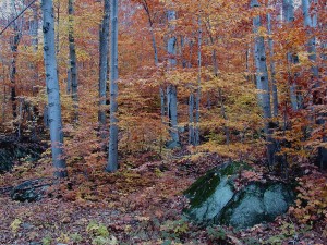
Stands like this one, made up primarily of beech,
were much more common in the pre-settlement forest of
northern New England and New York.
CC: We can’t generalize very much. Gordon Day, the ethnologist who worked for the National Museum of Man in Canada, was a forest ecologist before he was an ethnologist. He wrote a seminal paper on the effect of indigenous people on land in the Northeast. He basically came to say it was selective. In certain places, it occurred, in other places, it was a very light hand. He was the first person to say there was an interaction between fire and aboriginal populations, either deliberately or accidentally. Their habitations tend to have fire around them.
Then Cronon comes along and very rightfully discusses southern New England. Certainly the aboriginal populations living in the south in the oak forest and pine forest had more sedentary if not permanent agricultural settlements. They had much larger populations, obviously had a bigger effect on the forest, and that effect had to involve fire.
NW: And more fire-prone ecosystems…
CC: Not just fire-prone, but fire-dependant ecosystems. Which comes first? It’s a chicken-and-egg. Is it that there was a lot of fire because there was an aboriginal population there, or did the aboriginals come there because there were a lot of acorns and nuts that they wanted, so they started cultivating it? It’s a Gordian Knot that the anthropologists haven’t completely come clear on.
I split aboriginal effects into southern versus northern. It’s a little simpler in the north, because it’s less prominent both from a vegetational point of view and a cultural point of view. Was there real management going on, not just in terms of fire but in bringing in orchard groves and clearing land and having second growth fields? I’m looking at all possibilities, but coming down on the minimal to zero [effect] except in certain locations, such as the upper Connecticut River valley or the Champlain valley.
NW: People could look at your picture of a pre-settlement forest and think we should be trying to return to that. Is this picture you present a goal for us?
CC: I don’t consider it a goal for a couple of reasons. First, it’s unreachable, because we have so many legacies that we can’t turn back on. And it’s not just that we’ve lost chestnut and we’re losing butternut. But we really have gone through a bottleneck of land use, and it’s not really the recent stuff. The major blow in northern New England was the original clearance. We changed the soils, almost permanently. They’re still productive, they’re still soil, they haven’t been paved over, but certain things have been removed and other things have been given emphasis. We have natural progression, whether it is post-glacial migrations or cycles of species coming and going, getting established or holding on, and that’s been disrupted. We’re on a trajectory, and to think that we’re going to get back to the climate and the set of conditions in terms of land use that existed at that one point of time, you can’t force it back. Not least of which because we don’t know what it was in all those intricate details. We’re not really sure, for instance, of the range of larch. There’s some evidence it was part of the uplands until larch sawfly came along in the late 1800s.
Little things like that are going on all over the place. We can’t go back. It’s already happened. The other side of the picture is that for the most part, we have the same species that we had before and their overall life history is much as it was before. That’s Hugh Raup’s great conclusion: in northern New England, if you abandon it, it’s going to come back to forest. I extend that and say if you give it a generation or two as forest, it’s going to have much the same species composition. But you can’t consciously recreate it. Also the climate has changed enough so that the playing field isn’t the same.
NW: People are here to stay it looks like.
CC: People are here to stay, the climate is warmer, the depositional regime and the amount of nitrogen coming out of the sky has changed – we can’t ignore these, it’s a different field. I see nothing wrong with saying “let’s not go back to the past, but let’s promote in the futures some of the characteristics of the pre-settlement forest – less human disturbance, control of exotic species, paying attention to some details on compositional structure and the functioning of those systems.”
NW: Is there anything you’d like to add about your work?
CC: This is very much based in field ecology. It’s almost a paradox, because all of this research is archival work, but the original question arose out in the field and the work itself represents data from the field. It stands alone as a kind of a cultural archival project, but it’s truly field-based. We’re walking the footstep of the surveyors. You can read about it all you want, but you need to have a feeling for what’s going on in the field.
Discussion *